Source Points
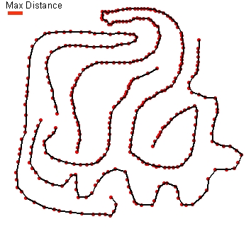
Result - Avoid Loops NOT selected
Go to ET GeoWizards 12.x User Guide
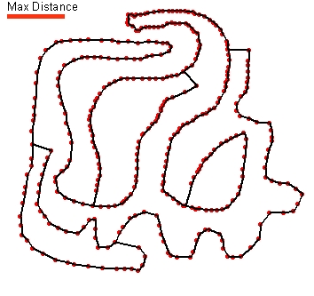
Connects each point of a point dataset to its closest neighbors to create polylines. The function does not require attributes that define which points should pertain to a single polyline or order of the points within the polylines (if your point data has such attributes use the Point To Polyline function instead). The function uses a robust algorithm and can be applied on datasets containing up to 2 million points.
Inputs:
Outputs:
Notes:
Examples:
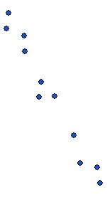
Source Points |
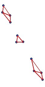
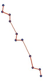
Result - Avoid Loops NOT selected |
Result - Avoid Loops selected |
|
|
|
|
 |
 |
ToolBox
implementation
(Go to TOP)
Command line syntax
ET_GPConnectUnstructuredPoints<input_dataset> <out_feature class> <cut_off>{avoid_loops}
Parameters
| Expression | Explanation |
|---|---|
| <input_dataset> | A Point, Polyline or Polygon feature class or feature layer |
| <out_feature class> | A String - the full name of the output feature class (A feature class with the same full name should not exist) |
| <cut_off> | A Double representing the maximum distance between two points to be considered neghbors - in the units of the spatial reference of the input dataset |
| {avoid_loops} | A Boolean indicating whether the function will try to avoid loops when connecting the points (see example above). |
Scripting syntax
ET_GPConnectUnstructuredPoints(input_dataset,out_feature class, cut_off,avoid_loops)
See the explanations above:
<> - required parameter
{} - optional parameter
| Copyright © Ianko Tchoukanski |