


Go to ET GeoWizards 12.x User Guide
Lines from Points Direction and Distance
Creates single segmented polylines from a point dataset that has in the attribute table fields which values represent direction and distance from each point to the target point.
Inputs:
| Polar | North Azimuth | South Azimuth | Quadrant Bearing |
|
|
|
|
Outputs:
Example :
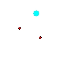
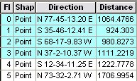
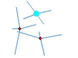
| Input Points | Point Attribute Table | Resulting Polylines |
 |
 |
 |
ToolBox
implementation
(Go to TOP)
Command line syntax
ET_GPLinesFromPointDirDist <input_dataset> <out_feature class><direction_field><distance_field> <NorthAzimuth | SouthAzimuth | Polar | QuadrantBearing> <DD | DMS | Radians | Gradians | Gons>
Parameters
| Expression | Explanation |
|---|---|
| <input_dataset> | A Point feature class or feature layer |
| <out_feature class> | A String - the full name of the output feature class (A feature class with the same full name should not exist) |
| <direction_field> | A String representing the name of a field in the in the attribute table of the input dataset field name. The field has the values for the directions of the lines to be created. |
| <distance_field> | A String representing the name of a field in the in the attribute table of the input dataset field name. The field has the values for the distances of the lines to be created. |
| <NorthAzimuth | SouthAzimuth | Polar | QuadrantBearing> | Direction Type. A String - the type of the output angle for the direction of the segments. |
| <DD | DMS | Radians | Gradians | Gons> | Direction
Unit. A String - the type of the output angle for the direction of
the segments. |
Scripting syntax
ET_GPLinesFromPointDirDist (input_dataset, out_feature class,direction_field,distance_field, direction_type, direction_unit)
See the explanations above:
<> - required parameter
{} - optional parameter