Builds a Triangulated Irregular Network from a feature layer
Inputs:
- A feature layer (Point, Polyline, Polygon)
- Type of output - ESRI TIN or PolygonZ TIN
- An elevation field - numeric field that will be used.
If the features have Z values, they can be used for elevation.
- If the output is ESRI TIN - triangulation
method to be used - "Mass points" or "Hard breaklines"
- If the output is PolygonZ TIN - the
Azimuth and the Altitude of the light source
Outputs:
- New ESRI TIN or PolygonZ feature class. All the polygons are triangles that comply with the Delaunay
criteria. See TIN notes for more information about Triangulated
Irregular Network.
- If the output is ESRI TIN and the input
features are polylines or polygons, they can be triangulated as Hard
breaklines.
- If the output is PolygonZ TIN, several
characteristics are calculated and added in the attribute table for each triangle.
- ET_ElMin - minimum elevation values for
each triangle
- ET_ElMax - maximum elevation values for
each triangle
- ET_ElMean - mean elevation values for each
triangle
- ET_Slope_D - the slope (maximum rate of
elevation change) of each triangle in Degrees (from 0 to 90)
- ET_Slope_P - the slope (maximum rate of
elevation change) of each triangle in percents (from 0 to 100%)
- ET_Aspect - the aspect - compass direction
of the slope (horizontal direction in which a slope faces) - 0 is North, 90 degrees - East, 180 degrees - South, 270 -
West of each triangle
- ET_ACode - aspect categories
- N - North ( 0 to 22.5 and 337.5 to
360)
- NE - North East (22,5 to 67.5)
- E - East (67.5 to 112.5)
- SE - South East (112.5 to 157.5)
- S - South (67.5 to 112.5)
- SW - South West (202.5 to 247.5)
- W - West (247.5 to 292.5)
- NW - North West (292.5 to 337.5)
- U - Undefined - Slope = 0
- ET_AreaZ - the 3D area of each triangle
Notes :
- The process goes through several steps
- Collecting the elevation points from the source layer. If the source is a polygon or
polyline layer, all the vertices are used.
- Removing duplicate points
- Creating the TIN structure
- Analyzing and storing the TIN
- In version 4.0 the TIN creation has been
redesigned and can handle much bigger datasets with improved speed. On
32 bit operating systems (Windows XP 32 bit or Windows 7 32 bit) with 4 GB of
RAM the function should work with no problems on
datasets with up to 6 million points. On 64 bit systems bigger datasets can
be processed depending on the available memory
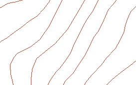
Example:
Source Layer (polyline)
Result TIN

ToolBox implementation
Command line syntax
- two different toolbox tools available depending on the type of the input TIN.
Check the colour coding for specifics.
| ETS_GPBuildESRITIN
<Input Dataset> <Out TIN> <Elevation Field>
<Triangulation type> |
| ETS_GPBuildPolygonZTIN <Input
Dataset> <Out Feature Class> <Elevation
Field> {Light Azimuth} {Light Altitude} |
Parameters
| Expression |
Explanation |
|
<Input Dataset> |
A Point, Polyline or
Polygon feature layer or feature class |
| <Out TIN> |
A String - the full name
of the output ESRI TIN |
| <Out Feature
Class> |
A String
- the full name of the output feature class. |
|
<Elevation Field> |
A String representing the
name of the field to be used as a source for the elevations |
|
<Triangulation type> |
A String - possible
values are "Mass points" and "Hard breaklines" |
|
{Light Azimuth} |
A Double representing azimuth
of the light source (0 to 360). 0 indicates North, 90 - East, 180 - South,
270 - West |
|
{Light Altitude} |
A Double representing the
altitude of the light source in degrees (0 to 90) |
Scripting syntax
ETS_GPBuildESRITIN (Input Dataset, Out TIN, Elevation Field,
Triangulation type)
ETS_GPBuildPolygonZTIN(Input Dataset, Out Feature Class,
Elevation Field, Light Azimuth, Light Altitude)
See the explanations above:
<> - required parameter
{} - optional parameter
.NET implementation
(Go to TOP)
BuildEsriTin(inFeatureClass As IFeatureClass, sOutTinName As String,
elevationField As String, triangulationType As String) As ITin
BuildPolygonZTin(inFeatureClass As IFeatureClass,
sOutFName As String, elevationField As String,
Optional dAzimuth As Double = 315,
Optional dAltitude As Double = 45) As IFeatureClass
| Copyright © Ianko Tchoukanski |