Converts a point data set to a polyline layer. Attaches to the polyline attribute table the values of the attributes for the first and last point that form a single polyline. If your point data does not have Polyline ID and Order attributes, you can try the Connect Unstructured Points function.
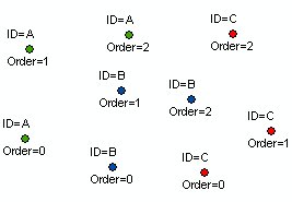
Source points
Source points attribute table
Resulting polylines: ID Field = [PolylineID], No Order Used
![Resulting polylines: ID Field = [PolylineID], No Order Used](images90/pnt2pl_ex13.jpg)
Resulting polylines: ID Field = [PolylineID], Order field = [PointOrder]
![Resulting polylines: ID Field = [PolylineID], Order field = [PointOrder]](images90/pnt2pl_ex14.jpg)
Parameters
| Expression | Explanation |
|---|---|
| Function Name | PointsToPolylines |
| <input dataset> | A String representing the input layer. Must be of Point type. |
| <output dataset> | A String - the full name of the output layer. |
| <ID Field> | A String - the name of the field which values will indicate the points used to form a single Polyline feature. |
| {Order Field} | A String - the name of a Numeric (integer or double) field which values will indicate the order in which the points describe the polylines.If no Order field is used the order is defined by the record number of the points. |
| {Z Field} | A String - the name of the field which values will be used for Z values of the vertices. "Features" can be used if the input points have Z. |
| {M Field} | A String - the name of the field which values will be used for M values of the vertices. "Features" can be used if the input points have M. |
| {Link Field} | A String - the name of a field to be used as a link between the input points and the output. The values for the first and last point that will form a single polyline will be added to the polyline attribute table. |
ETGWPath used in the table below is the full path to ETGWRun.exe (E.G. "C:\Program Files\ETSpatial Techniques\ETGeo Wizards\ETGWRun.exe")
| Language | Syntax |
|---|---|
| Python | subprocess.call([ETGWPath, "PointsToPolylines", "input dataset", "output dataset", "ID Field", "Order Field", "Z Field", "M Field","Link Field"]) |
| .NET using ETGWRun.exe | StartInfo.FileName = ETGWPath StartInfo.Arguments = "PointsToPolylines" "input dataset" "output dataset" "ID Field" "Order Field" "Z Field" "M Field" "Link Field" |
| .NET using ETGWOutX.dll | PointsToPolylines(input dataset, output dataset, ID Field, Order Field, Z Field, M Field,Link Field) |
| ArcPy | arcpy.PointsToPolylines(input dataset, output dataset, ID Field, "Order Field", "Z Field", M Field, Link Field) |
Notes:
<> - required parameter
{} - optional parameter
The argument separator for StartInfo.Arguments is space. If a string might contain a space, you need to double quote it.