
Disperses (separates) the coincident points. The first point in a location preserves its coordinates. Every next point found in the same location is moved within user defined maximum offset distance from its original location.
Input Dataset
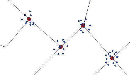
Dispersed Randomly
Dispersed Regularly

Parameters
| Expression | Explanation |
|---|---|
| Function Name | DispersePoints |
| <input dataset> | A String representing the input layer. Must be of Polygon type. |
| <output dataset> | A String - the full name of the output layer. |
| <Tolerance> | A Double representing the Maximum allowed offset - the duplicate points will move no further than this tolerance from their original location. |
| <Disperse Mathod< | A string defining how the points will be dispersed. Valid values - "Random" or "Regular". |
ETGWPath used in the table below is the full path to ETGWRun.exe (E.G. "C:\Program Files\ETSpatial Techniques\ETGeo Wizards\ETGWRun.exe")
| Language | Syntax |
|---|---|
| Python | subprocess.call([ETGWPath, "DispersePoints", "input dataset", "output dataset", "Tolerance", "Disperse Mathod"]) |
| .NET using ETGWRun.exe | StartInfo.FileName = ETGWPath StartInfo.Arguments = "DispersePoints" "input dataset" "output dataset" "Tolerance" "Disperse Mathod" |
| .NET using ETGWOutX.dll | DispersePoints(input dataset, output dataset, Tolerance, Disperse Mathod) |
| ArcPy | arcpy.DispersePoints(input dataset, output dataset, "Tolerance", "Disperse Mathod") |
Notes:
<> - required parameter
{} - optional parameter
The argument separator for StartInfo.Arguments is space. If a string might contain a space, you need to double quote it.