Determines for each polygon of the dataset the adjacent polygons and stores the result in the attribute table as a comma delimited string.
Notes:
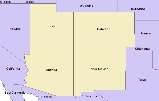
Example:
| State Name | ET Adj | ET Count |
|---|---|---|
| Arizona | California, Sonora, Nevada, NewMexico, BajaCalifornia, Utah | 6 |
| Colorado | NewMexico, Utah, Wyoming, Kansas,Nebraska, Oklahoma | 6 |
| New Mexico | Chihuahua, Sonora, Arizona, Colorado, Oklahoma, Texas | 6 |
| Utah | Nevada, Arizona, Colorado, Wyoming, Idaho | 5 |
Parameters
| Expression | Explanation |
|---|---|
| Function Name | PolygonAdjacency |
| <input dataset> | A String representing the input layer. Must be of Polygon type. |
| <output dataset> | A String - the full name of the output layer. |
| {Link Field} | A Double representing the Generalization tolerance (in the units of the spatial reference of the input layer. |
ETGWPath used in the table below is the full path to ETGWRun.exe (E.G. "C:\Program Files\ETSpatial Techniques\ETGeo Wizards\ETGWRun.exe")
| Language | Syntax |
|---|---|
| Python | subprocess.call([ETGWPath, "PolygonAdjacency", "input dataset", "output dataset", "Link Field"]) |
| .NET using ETGWRun.exe | StartInfo.FileName = ETGWPath StartInfo.Arguments = "PolygonAdjacency" "input dataset" "output dataset" "Link Field" |
| .NET using ETGWOutX.dll | PolygonAdjacency(input dataset, output dataset, Link Field) |
| ArcPy | arcpy.PolygonAdjacency(input dataset, output dataset, "Link Field") |
Notes:
<> - required parameter
{} - optional parameter
The argument separator for StartInfo.Arguments is space. If a string might contain a space, you need to double quote it.