Google Earth is a powerful tool for viewing,
creating and sharing GIS data. The latest improvements in the KML format allow
storing attributes as structured data, which makes possible exchange and even editing of GIS data
using Google Earth. Google Earth comes in four different versions (from
Free to Enterprise). Make sure to read the Google Earth
license agreement before using it.
What is KML
Keyhole Markup Language (KML) is an XML - based
language for managing the display of geo spatial data in Google Maps and Google
Earth. Since a KML file is a text file, its size might become quite large.
Google Earth also takes a lot of RAM when large KML files are loaded. If
possible split your datasets to subsets before converting them to KML.
What is KMZ
The compressed version of the KML with the
extension KMZ. Actually this is a zipped archive and the contents can be
extracted with any zip program. A KMZ file can contain one or more KML files
together with images etc. The export function of ET GeoWizards expect a full
file name (with the extension). The extension of the output file defines whether
the file will be compressed (KMZ) or not (KML)
Google Earth version
ET GeoWizards exports KML version 2.2 files (this
is the KML version which introduced support for attributes called in KML
"ExtendedData"). Since it is impossible to find out which exactly version of
Google Earth starts supporting KML 2.2, we recommend using Google Earth 4.2 or
above.
Google Earth projection
For its reference system, KML uses Geographic
Coordinate System (GCS) with WGS84 datum. In ArcGIS this projection is called
GCS_WGS_1984. The export to Google Earth functions of ET GeoWizards
project the data on the fly to GCS_WGS_1984. If the source data is in a
projection that have different datum, the functions of ET GeoWizards do on the
fly geographic transformations on the data.
If the input data does not have a projection
associated with it or have so called "Unknown" coordinate system, the data
cannot be exported to KML.
If the export functions cannot find an
appropriate geographic transformation to project the input data to
GCS_WGS_1984, they will not export the data. This might happen if the input
data is in a very specific or outdated projection.
Consideration when exporting to Google Earth
The export function of ET
GeoWizards supports multipart features, which are exported as MultiGeometry
in the KML file. These features will consist of several not connected
geometries and will have a single label point. If the same features
are imported back, each geometry will be created as a single part feature
with the same attributes.
The export functions of ET
GeoWizards allow creating Labels for each Polyline and Polygon
features. The Labels are created as follows:
For polygons - the label points of the polygons.
For polylines - the middle point of the polyline
Using Labels is convenient way to display the
name of a polyline or polygon feature. Since Labels are part of the
feature they are also linked to the feature attributes, which can be
displayed by clicking on the Label as well as by clicking on the feature.
Point features are always labelled and the user can not turn the label option off.
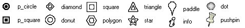
Point Symbols. ET GeoWizards uses a set of
the standard Google Earth marker symbols to display point features and
Labels for polyline and polygon features. The user
can select the marker to be used for each feature class. The symbols that
can be used are:
The size and the color of the symbols are taken from:
Size - assigned by the user
Color - randomly assigned
Exporting elevations: The export functions
of ET GeoWizards allow three ways of exporting Z values for the features.
Z values from geometry - Only available
if the exported dataset to be exported has Z values (PointZ, PolylineZ,
PolygonZ).
Z values from a field - A numeric field
is required
Constant Z values for all features
Note that Google Earth uses elevation values
in Meters. If the Z values of the dataset are in Feet, the user needs to
indicate this in the export procedure.
Representation of the elevations in Google
Earth:
Z Type - how the Z values will be
interpreted by Google Earth
Absolute - Sets the altitude of the
coordinate relative to sea level, regardless of the elevation of the
Google Earth terrain beneath the feature.
Relative - Sets the altitude of the
feature relative to the Google Earth terrain in a particular
location.
NONE - the Z values are ignored -
the feature will be displayed on the Google Earth surface
Extrusion - Specifies whether to connect
the geometry to the ground.
Attributes. All attributes of the features
are exported and can be displayed in Google Earth. To display the
attributes select the feature or its Label point.