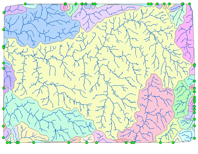
Delineates the Catchment areas based on a Single Direction Network (SDN). Based on the input SDN network (for example rivers) the function finds the Sinks (Outlets), trverses the SDN upstream and outputs polygons representing the catchment areas for each sink (outlet).
Input rivers together with the output Sinks (Outlets) and delineated catchment areas.
Parameters
| Expression | Explanation |
|---|---|
| Function Name | SDNDelineateCatchment |
| <Network to Use> | A String - the full name of the Network file (.etn). |
| <output catchment dataset> | A String - the full name of the output catchments polygon layer. |
| <output sinks dataset> | A String - the full name of the output sinks/outlets point layer. |
| {Input Barrier Points} | A String representing the input layer with barrier points. Must be of Point type. |
ETGWPath used in the table below is the full path to ETGWRun.exe (E.G. "C:\Program Files\ETSpatial Techniques\ETGeo Wizards\ETGWRun.exe")
| Language | Syntax |
|---|---|
| Python | subprocess.call([ETGWPath, "SDNDelineateCatchment", "Network to Use", "output catchment dataset","output sinks dataset", "Input Barrier Points"]) |
| .NET using ETGWRun.exe | StartInfo.FileName = ETGWPath StartInfo.Arguments = "SDNDelineateCatchment" "Network to Use" "output catchment dataset" "output sinks dataset" "Input Barrier Points" |
| .NET using ETGWOutX.dll | SDNDelineateCatchment(Network to Use, output catchment dataset, output sinks dataset,Input Barrier Points) |
| ArcPy | arcpy.SDNDelineateCatchment(Network to Use, output catchment dataset, output sinks dataset, Input Barrier Points) |
Notes:
<> - required parameter
{} - optional parameter
The argument separator for StartInfo.Arguments is space. If a string might contain a space, you need to double quote it.