Identifies if a Single Direction Network (SDN) has loops and creates a Polyline layer that represents the loops. The source data for the SDN should be edited and the loops corrected
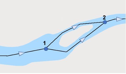
A typical river with an island. The flow direction in both channels is the same (from Node 1 to Node 2), so no loop is present
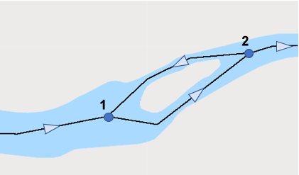
The transported agent travels from node 1 to Node 2 then returns from Node 2 to Node 1 - this is a loop. The source data for the network should be corrected.
Parameters
| Expression | Explanation |
|---|---|
| Function Name | SDNCheckForLoops |
| <Network to Use> | A String - the full name of the Network file (.etn). |
| <Output Points> | A String - the full name of the output Point layer. |
ETGWPath used in the table below is the full path to ETGWRun.exe (E.G. "C:\Program Files\ETSpatial Techniques\ETGeo Wizards\ETGWRun.exe")
| Language | Syntax |
|---|---|
| Python | subprocess.call([ETGWPath, "SDNCheckForLoops", "Network to Use", "Output Points"]) |
| .NET using ETGWRun.exe | StartInfo.FileName = ETGWPath StartInfo.Arguments = "SDNCheckForLoops" "Network to Use" "Output Points" |
| .NET using ETGWOutX.dll | SDNCheckForLoops(Network to Use,Output Points) |
| ArcPy | arcpy.SDNCheckForLoops(Network to Use,Output Points) |
Notes:
<> - required parameter
{} - optional parameter
The argument separator for StartInfo.Arguments is space. If a string might contain a space, you need to double quote it.