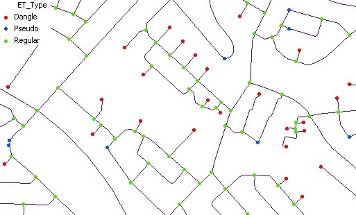
Analyzes the nodes of a polyline layer and exports them as a point layer.
Parameters
| Expression | Explanation |
|---|---|
| Function Name | ExportNodes |
| <input dataset> | A String representing the input layer. Must be of Polyline type. |
| <output dataset> | A String - the full name of the output layer. |
| <Export Dangling> | A Boolean indicating whether the Dangling nodes will be exported |
| <Export Pseudo> | A Boolean indicating whether the Pseudo nodes will be exported. |
| <Export Regular> | A Boolean indicating whether the Regular nodes will be exported |
| <Link Field> | A String representing the name of the field which values will be used as links between the nodes and the source polylines |
ETGWPath used in the table below is the full path to ETGWRun.exe (E.G. "C:\Program Files\ETSpatial Techniques\ETGeo Wizards\ETGWRun.exe")
| Language | Syntax |
|---|---|
| Python | subprocess.call([ETGWPath, "ExportNodes", "input dataset", "output dataset", "Export Dangling", "Export Pseudo", "Export Regular", "Link Field"]) |
| .NET using ETGWRun.exe | StartInfo.FileName = ETGWPath StartInfo.Arguments = "ExportNodes" "input dataset" "output dataset" "Export Dangling" "Export Pseudo" "Export Regular" "Link Field" |
| .NET using ETGWOutX.dll | ExportNodes(input dataset, output dataset, Export Dangling, Export Pseudo, Export Regular, Link Field) |
| ArcPy | arcpy.ExportNodes(input dataset, output dataset, "Export Dangling" , "Export Pseudo", "Export Regular", "Link Field") |
Notes:
<> - required parameter
{} - optional parameter
The argument separator for StartInfo.Arguments is space. If a string might contain a space, you need to double quote it.