Generates uniform (regularly spaced) points located in the polygons of the input polygon dataset. The distance between the points for each polygon can be the same or different - based on the values in a numeric field of the input polygon feature class. The user can specify the rotation angle for the resulting point grid.
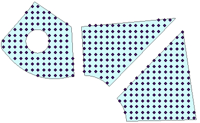
Distance between points = 10, Rotational angle = 0
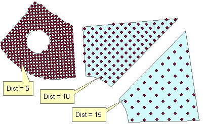
Original polygons labeled with the values in field to be used as a source for getting the distance between the points. Rotational angle = "Along the longest Side"
Parameters
| Expression | Explanation |
|---|---|
| Function Name | PointGridsInPolygons |
| <input dataset> | A String representing the input layer. Must be of Polygon type. |
| <output dataset> | A String - the full name of the output layer. |
| {Size} | A Double representing distance between the grid points. |
| {Size Field} | A String representing the name of a field in the in the attribute table of the input dataset. The field has the values for the distance between the grid points. |
| <Angle From> | Required. A String -This parameter defines what will
be the source rotation of the grids:
|
| {Angle} | A Double representing the rotation angle of the grids |
| {Angle Field} | A String representing the name of a field in the in the attribute table of the input dataset field name. The field has the values for the angle of the grids to be created. |
ETGWPath used in the table below is the full path to ETGWRun.exe (E.G. "C:\Program Files\ETSpatial Techniques\ETGeo Wizards\ETGWRun.exe")
| Language | Syntax |
|---|---|
| Python | subprocess.call( [ETGWPath, "PointGridsInPolygons", "input dataset", "output dataset", "Size", "", "Angle From", "Angle", ""]) |
| .NET using ETGWRun.exe | StartInfo.FileName = ETGWPath StartInfo.Arguments = "PointGridsInPolygons" "input dataset" "output dataset" "Size" "" "Angle From" "Angle" "" |
| .NET using ETGWOutX.dll | PointGridsInPolygons(input dataset, output dataset, Size, "", Angle From, Angle, "") |
| ArcPy | arcpy.PointGridsInPolygons(input dataset, output dataset , "Size", "", "Angle From", "Angle", """) |
Notes:
<> - required parameter
{} - optional parameter
The argument separator for StartInfo.Arguments is space. If a string might contain a space, you need to double quote it.