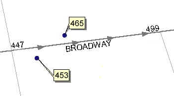
Uses a reference polyline (street centerlines) layer to assign addresses to the points from a point layer. Allows transfer of any additional attributes.
Address range
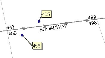
Single range
| Expression | Explanation |
|---|---|
| Function Name | ReverseGeocoding |
| <input dataset> | A String representing the input layer. Must be of Point type. |
| <reference dataset> | A String representing the reference layer. Must be of Polyline type |
| <output dataset> | A String - the full name of the output layer. |
| <search tolerance> | A Double representing the Search tolerance to be used. The units of the tolerance are the units of spatial reference of the input dataset if KeepSourceSref = TRUE. Otherwise - the units of spatial reference of the reference dataset. |
| <Type> | A String indicating the type of address data - valid values - Single, Continuous, Address |
| {LeftFromField} | A String representing a field name in the Reference dataset source for the start address on the left side of the road. If the type is Continuous - the start address |
| {LeftToField} | A String representing a field name in the Reference dataset source for the end address on the left side of the road. If the type is Continuous - the end address |
| {RightFromField} | A String representing a field name in the Reference dataset source for the start address on the right side of the road. If the type is Continuous not used. |
| {RightToField} | A String representing a field name in the Reference dataset source for the end address on the right side of the road. If the type is Continuous not used. |
| {AdditionalFields} | A String representing a list of additional field names which values will be transferred to the points - separator - semi-colon (;) - Example: "field1; field2; ...." |
| {KeepSourceSref} | A Boolean indicating whether the output to have the spatial reference of the input layer. If False or 0, the spatial reference of the reference layer will be used. |
ETGWPath used in the table below is the full path to ETGWRun.exe (E.G. "C:\Program Files\ETSpatial Techniques\ETGeo Wizards\ETGWRun.exe")
| Language | Syntax |
|---|---|
| Python | subprocess.call([ETGWPath, "ReverseGeocoding", "input dataset", "reference dataset", "output dataset", "search tolerance", "Type", "LeftFromField", "LeftToField", "RightFromField", "RightToField", "AdditionalFields", "KeepSourceSref"]) |
| .NET using ETGWRun.exe | StartInfo.FileName = ETGWPath StartInfo.Arguments = "ReverseGeocoding" "input dataset" "reference dataset" "output dataset" "search tolerance" Type" "LeftFromField" "LeftToField" "RightFromField" "RightToField" "AdditionalFields" "KeepSourceSref" |
| .NET using ETGWOutX.dll | ReverseGeocoding(input dataset,reference dataset, output dataset, search tolerance, Type, LeftFromField, LeftToField, RightFromField, RightToField, AdditionalFields, KeepSourceSref) |
| ArcPy | arcpy.ReverseGeocoding(input dataset, reference dataset, output dataset, "search tolerance", "Type", "LeftFromField", "LeftToField", "RightFromField", "RightToField", "AdditionalFields", "KeepSourceSref") |
Notes:
<> - required parameter
{} - optional parameter
The argument separator for StartInfo.Arguments is space. If a string might contain a space, you need to double quote it.