- Join Type = "One To Many" - one feature from the Join Dataset can be joined to many features of the target dataset,
but each feature from the Target Dataset will receive the attributes of only ONE of the features from the Source Dataset:
- Point to Polygon - the polygon will get the attributes of the deepest point inside the polygon (farthest to the polygon boundary)
or if there is no point inside the closest point to the polygon (within the search tolerance)
Example: Points to Polygons - Search Tolerance = 0
- Point to Point, Point To Polyline, Point To Multipoint - the target will get the attributes of the closest polyline
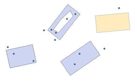
- Polyline to Polygon - the polygon will get the attributes of the polyline with the longest intersection with the polygon
or if there is no intersecting polyline the closest polyline to the polygon (within the search tolerance)
Example: Polylines to Polygons - Search Tolerance = 0
- Polyline to Point, Polyline To Polyline, Polyline To Multipoint - the target will get the attributes of the closest point
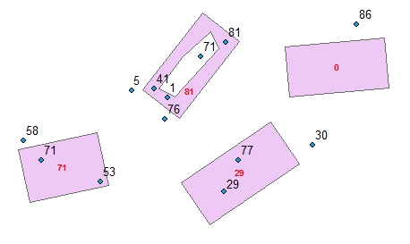
- Polygon to Point - the point will get the attributes of the polygon:
- If the point is within the polygon - the polygon with largest distance to the boundary
- If the point is not in any polygon - the closest polygon within the search tolerance.
Example: Polygons to Points - Search Tolerance = 0 - Update Rule = "Sum"
- Polygon to Polyline - the polyline will get the attributes of the polygon with longest intersection. If the polyline does not intersect any polygon - the closest polygon within the search tolerance.
- Polygon to Polygon - the polygon will get the attributes of the polygon with largest area of intersection. If the polygon does not intersect any source polygon - the closest polygon within the search tolerance.
- Point to Polygon - the polygon will get the attributes of the deepest point inside the polygon (farthest to the polygon boundary)
or if there is no point inside the closest point to the polygon (within the search tolerance)
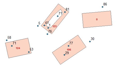
- Join Type = "Many To Many" - the target feature will get the attributes of all source features within the search tolerance
according to the user specified update rule for each field to be joined.
Example: Points to Polygons - Search Tolerance = 0
Example: Points to Polygons - Search Tolerance = 0 Keep All Target Features = FALSE. The feature with no joins is missing in the output.
- [ET_Count] - the number of source features joined to the target feature.
- [ET_CountIn] - if the target is polygon or polyline - the number of the joined features that intersect each target feature. Note that if the search tolerance is larger than 0 the number of the joined features might be larger than the number of intersecting features
- [ET_LengthIn] - if the target is polygon and the source polyline - the sum of the length of the polylines intersecting the target polygon
- [ET_LengthIn] - if the target and the source are polygons - the sum of the area of the polygons intersecting the target polygon