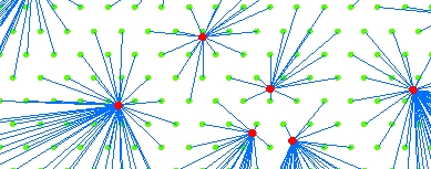
Creates a polyline feature class representing the shortest distance between centers (point dataset) and Destinations (Point, Polyline or Polygon datasets). The Destinations are allocated to the closest Center.
| Expression | Explanation |
|---|---|
| Function Name | SpiderDiagram |
| <Centers Dataset> | A String representing the input layer. Must be of Point type. |
| <Destinations Dataset> | A String representing the reference layer. Must be of Polyline type |
| <output dataset> | A String - the full name of the output layer. |
| < CutOff Distance> | A Double representing the Cut-Off distance to be used. The units of the tolerance are the units of spatial reference of the Centers Dataset if KeepSourceSref = TRUE. Otherwise - the units of spatial reference of the Destinations Dataset. |
| {KeepSourceSref} | A Boolean indicating whether the output to have the spatial reference of the input layer. If False or 0, the spatial reference of the reference layer will be used. |
ETGWPath used in the table below is the full path to ETGWRun.exe (E.G. "C:\Program Files\ETSpatial Techniques\ETGeo Wizards\ETGWRun.exe")
| Language | Syntax |
|---|---|
| Python | subprocess.call([ETGWPath, "SpiderDiagram", "Centers Dataset", "Destinations Dataset", "output dataset", " CutOff Distance", "KeepSourceSref"]) |
| .NET using ETGWRun.exe | StartInfo.FileName = ETGWPath StartInfo.Arguments = "SpiderDiagram" "Centers Dataset" "Destinations Dataset" "output dataset" "CutOff Distance" "KeepSourceSref" |
| .NET using ETGWOutX.dll | SpiderDiagram(Centers Dataset,Destinations Dataset, output dataset, CutOff Distance, KeepSourceSref) |
| ArcPy | arcpy.SpiderDiagram(Centers Dataset, Destinations Dataset, output dataset, "CutOff Distance", "KeepSourceSref") |
Notes:
<> - required parameter
{} - optional parameter
The argument separator for StartInfo.Arguments is space. If a string might contain a space, you need to double quote it.