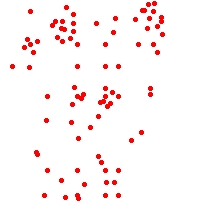
Reduces the number of points in a point dataset based on their spatial location.
Input Dataset
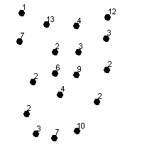
Result Dataset labeled with the number of points they represent (ET_Count field)
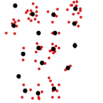
Overlay
| Expression | Explanation |
|---|---|
| Function Name | ThinPoints |
| <input dataset> | A String representing the input layer. Must be of Point type. |
| <output dataset> | A String - the full name of the output layer. |
| <tolerance> | A Double representing the Generalization tolerance (in the units of the spatial reference of the input dataset) to be used |
| {LinkName} | A String representing the full name of the optional output layer. |
Running the function
ETGWPath used in the table below is the full path to ETGWRun.exe (E.G. "C:\Program Files\ETSpatial Techniques\ETGeo Wizards\ETGWRun.exe")
| Language | Syntax |
|---|---|
| Python | subprocess.call([ETGWPath, "ThinPoints", "input dataset", "output dataset", "tolerance", "LinkName"]) |
| .NET using ETGWRun.exe | StartInfo.FileName = ETGWPath StartInfo.Arguments = "ThinPoints" "input dataset" "output dataset" "tolerance" "LinkName" |
| .NET using ETGWOutX.dll | ThinPoints(input dataset, output dataset, tolerance, LinkName) |
| ArcPy | arcpy.ThinPoints(input dataset, output dataset, "tolerance" , "LinkName") |
Notes:
<> - required parameter
{} - optional parameter
The argument separator for StartInfo.Arguments is space. If a string might contain a space, you need to double quote it.