Generates uniform (regularly spaced) points located in the polygons of the input polygon dataset. The number of points per polygon can be constant or different for each polygon - based on the values in a numeric field of the input polygon feature class. The distance between the points is interpolated for each polygon. The user can specify the rotation angle for the resulting point grid.
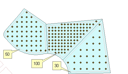
Original polygons labeled with the values in field to be used as a source for getting the number of points to be generated and the resulting points.Rotational angle = 0, Minimum distance to boundary = 5
Original polygons labeled with the values in
field to be used as a source for getting the number of points to be
generated and the resulting points.
Rotational angle = "Along the
longest Axis", Minimum distance to boundary = 5
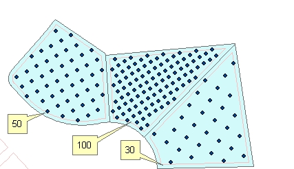
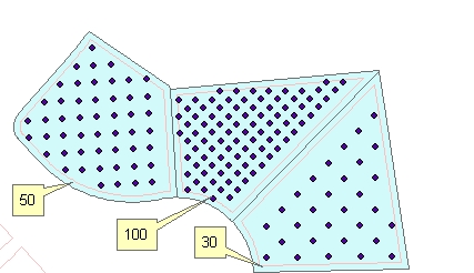
Original polygons labeled with the values in field to be used as a source for getting the number of points to be generated and the resulting points. Rotational angle = "Along the longest side", Minimum distance to boundary = 5
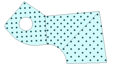
50 points per polygon. Rotational angle = "Along the longest side", Minimum distance to boundary = 0
Parameters
| Expression | Explanation |
|---|---|
| Function Name | UniformPointsInPolygons |
| <input dataset> | A String representing the input layer. Must be of Polygon type. |
| <output dataset> | A String - the full name of the output layer. |
| <Angle From> | Required. A String -This parameter defines what will
be the source rotation of the grids:
|
| {Number Points} | An Integer representing the number of points per polygon to be created. |
| {Number Points Field} | A String representing the name of a field in the in the attribute table of the input dataset. The field has the values for the number points per polygon to be created. |
| {Angle} | A Double representing the rotation angle of the grids |
| {Angle Field} | A String representing the name of a field in the in the attribute table of the input dataset field name. The field has the values for the angle of the grids to be created. |
| {Distance to Boundary} | A Double representing the minimum distance to the polygon boundary |
ETGWPath used in the table below is the full path to ETGWRun.exe (E.G. "C:\Program Files\ETSpatial Techniques\ETGeo Wizards\ETGWRun.exe")
| Language | Syntax |
|---|---|
| Python | subprocess.call( [ETGWPath, "UniformPointsInPolygons", "input dataset", "output dataset", "Angle From", "Number Points", "Number Points Field", "Angle", "","Distance to Boundary"]) |
| .NET using ETGWRun.exe | StartInfo.FileName = ETGWPath StartInfo.Arguments = "UniformPointsInPolygons" "input dataset" "output dataset" "Angle From" "Number Points" "Number Points Field" "Angle" "" "Distance to Boundary" |
| .NET using ETGWOutX.dll | UniformPointsInPolygons(input dataset, output dataset, Angle From, Number Points, Number Points Field, Angle, "", Distance to Boundary) |
| ArcPy | arcpy.UniformPointsInPolygons(input dataset, output dataset , "Angle From", "Number Points", "Number Points Field", "Angle", "", "Distance to Boundary") |
Notes:
<> - required parameter
{} - optional parameter
The argument separator for StartInfo.Arguments is space. If a string might contain a space, you need to double quote it.