Dissolve field = “Dissolve”
Go to ET GeoWizards 12.x User Guide
Go to ToolBox
Implementation
Dissolves (aggregates) polygons based on user specified attributes. The resulting polygon
data set does not contain multi-part polygons
Inputs
Outputs
Notes:
Example:
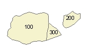
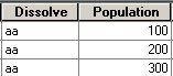
| Input Layer Dissolve field = “Dissolve” |
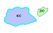
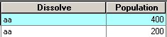
After Dissolve: |
|
|
ToolBox
implementation
(Go to TOP)
Command line syntax
ET_GPDissolvePolygons<input_dataset> <out_feature class> <dissolve_field_list> {Update_Rules_List}
Parameters
| Expression | Explanation |
|---|---|
| <input_dataset> | A Polyline feature class or feature layer |
| <out_feature class> | A String - the full name of the output feature class (A feature class with the same full name should not exist) |
| {dissolve_field_list} | A String - a list of field names to be used for dissolving. |
| {Update_Rules_List} | A String - a list of fields with their update rules. |
Scripting syntax
ET_GPDissolvePolygons(input_dataset, out_feature class, dissolve_field_list,Update_Rules_List)
See the explanations above:
<> - required parameter
{} - optional parameter
Example Python script:
|
import arcpy arcpy.ImportToolbox("C:/Program Files/ET SpatialTechniques/ET GeoWizards 11.0 for ArcGIS 10.1/ET GeoWizards.tbx") arcpy.gp.toolbox = "C:/Program Files/ET SpatialTechniques/ET GeoWizards 11.0 for ArcGIS 10.1/ET GeoWizards.tbx" input_dataset = "C:\\data\\suburbs.shp" result = "C:\\data\\fgdb_test.gdb\\dissolved" arcpy.gp.ET_GPDissolvePolygons(input_dataset, result, "Name;Type", "Population Sum; City First) |
| Copyright © Ianko Tchoukanski |