Clips a raster dataset with the polygons of the input polygon feature class.
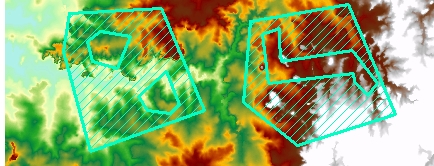
Input raster and clip polygons
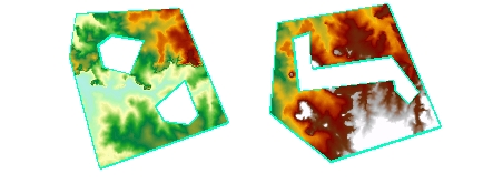
Result raster
Parameters
| Expression | Explanation |
|---|---|
| Function Name | ClipRasterWithPolygons |
| <input raster> | A String representing the input raster dataset. |
| <output raster> | A String - the full name of the output raster. |
| <clip dataset> | Clip Polygon dataset |
ETSPath used in the table below is the full path to ETSRun.exe (E.G. "C:\Program Files\ETSpatial Techniques\ETSurface\ETSRun.exe")
| Language | Syntax |
|---|---|
| Python | subprocess.call([ETSPath, "ClipRasterWithPolygons", "input raster", "output raster", "clip dataset"]) |
| .NET using ETSRun.exe | StartInfo.FileName = ETSPath StartInfo.Arguments = "ClipRasterWithPolygons" "input raster" "output raster" "clip dataset" |
| .NET using ETSOutX.dll | ClipRasterWithPolygons(input raster, output raster, clip dataset) |
| ArcPy | arcpy.ClipRasterWithPolygons("input raster", "output raster", "clip dataset") |
Notes:
<> - required parameter
{} - optional parameter
The argument separator for StartInfo.Arguments is space. If a string might contain a space, you need to double quote it.