Derives the catchment areas of the input features (Sources) using their spatial location and the weights from a weight raster. The function allocates the cells of the output raster to the sources based on minimum cost to reach a source from the cell. The cost is calculated as distance from the cell to the source multiplied by the weight of the cells of the cost raster. The NODATA values in the cost raster are considered prohibitive cost.
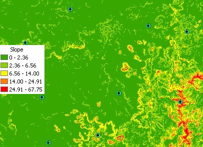
Source points. Cost Raster - Slope raster of digital terrain model used in the example.
The scenario might be to allocate emergency response areas to centers in a mountain - the larger the slope - the lower the accessibility.
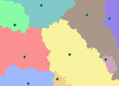
The resulting allocation raster.
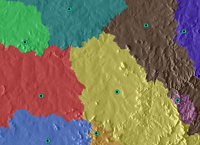
The resulting allocation raster over the Hillshade of the terrain. Illustrates that the boundaries of the zones allocated to the Centers are on very steep terrain (slope is big - the cost is high).
Parameters
| Expression | Explanation |
|---|---|
| Function Name | CostAllocationRaster |
| <InputFeatures> | A String - the full path to the input feature dataset. |
| <output raster> | A String - the full name of the output raster. |
| <CostRaster> | A String representing the cost raster dataset. |
| <IDField> | A String representing the name of the field in the input point feature class to be used as point ID. |
| <CutOff> | A Double representing the cut off cost - the value of the cells with larger than this cost (distance x weight) to reach will be set to NODATA. |
ETSPath used in the table below is the full path to ETSRun.exe (E.G. "C:\Program Files\ETSpatial Techniques\ETSurface\ETSRun.exe")
| Language | Syntax |
|---|---|
| Python | subprocess.call([ETSPath, "CostAllocationRaster", "InputFeatures", "output raster", "CostRaster", "IDField", "CutOff"]) |
| .NET using ETSRun.exe | StartInfo.FileName = ETSPath StartInfo.Arguments = "CostAllocationRaster" "InputFeatures" "output raster" "CostRaster" "IDField" "CutOff" |
| .NET using ETSOutX.dll | CostAllocationRaster(InputFeatures, output raster, CostRaster, IDField, CutOff) |
| ArcPy | arcpy.CostAllocationRaster("InputFeatures", "output raster", "CostRaster", "IDField", "CutOff") |
Notes: