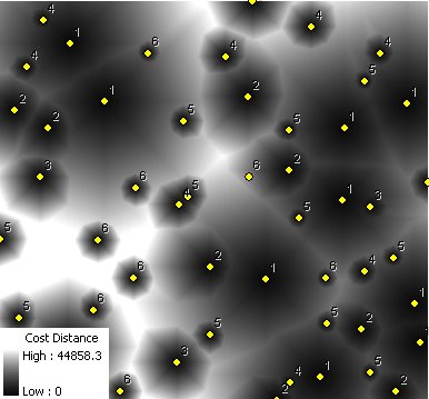
Calculates for each cell of the output raster the least cost to reach one of the sources of the input point feature class. The cost is calculated as distance from the cell to the source multiplied by the weight of the source. The smaller the weight value of a source is, the greater the influence of the source is.
The performance of the function depends very much on the difference between the smallest and largest weights. The larger this difference is, the slower the function will be.
The performance of the function depends very much on the difference between the smallest and largest weights. The larger this difference is, the slower the function will be.
Points (Sources) labeled with their weights.
Parameters
| Expression | Explanation |
|---|---|
| Function Name | CostDistanceSource |
| <InputFeatures> | A String - the full path to the input feature dataset. |
| <output raster> | A String - the full name of the output raster. |
| <CellSize> | A Double representing the cell size of the output raster. |
| <WeightField> | A String representing the name of the field in the input point feature class that are going to be used as weights. |
| <CutOff> | A Double representing the cut off cost - the value of the cells with larger than this cost (distance x weight) to reach will be set to NODATA. |
ETSPath used in the table below is the full path to ETSRun.exe (E.G. "C:\Program Files\ETSpatial Techniques\ETSurface\ETSRun.exe")
| Language | Syntax |
|---|---|
| Python | subprocess.call([ETSPath, "CostDistanceSource", "InputFeatures", "output raster", "CellSize", "WeightField", "CutOff"]) |
| .NET using ETSRun.exe | StartInfo.FileName = ETSPath StartInfo.Arguments = "CostDistanceSource" "InputFeatures" "output raster" "CellSize" "WeightField" "CutOff" |
| .NET using ETSOutX.dll | CostDistanceSource(InputFeatures, output raster, CellSize, WeightField, CutOff) |
| ArcPy | arcpy.CostDistanceSource("InputFeatures", "output raster", "CellSize", "WeightField", "CutOff") |
Notes: