Generates a Flow Accumulation raster using the D-infinity algorithm (Tarboton, 1997).
Inputs:
A D-infinity Flow Direction raster dataset.
Stream Initiation Threshold value (optional)
A D8 Flow Direction raster dataset (optional)
Output raster name and format
Outputs:
A Floating raster representing the Flow Direction according to the
D-infinity (Deterministic Infinity) method.
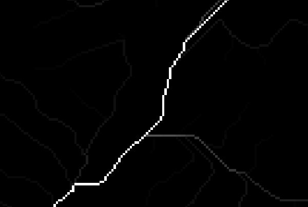
Example:
An example of Flow Accumulation D-infinity result (above) and Flow Accumulation D8 (below).
Note the dispersion of flow in the D-infinity result compared with the concentrated flow in D8.
Notes:
The value for each cell in the Flow Accumulation raster is the total number of cells which flow into it
including the cell itself. So for a cell with no inflowing cells the value will be 1.
The D-infinity flow algorithm allows flow divergence. This means that the value accumulated in a cell can be directed to one or two
neighboring cells depending on the flow direction angle. This is a better representation of flow on divergent slopes.
By applying a Threshold value to the Flow Accumulation raster we can determine the cells which form a Stream network. All cells with Flow
Accumulation value above the threshold are considered to be part of a stream.
The flow direction after Stream Initiation is better represented by the D8 single flow algorithm. The function allows for the specification of
a Stream Initiation Threshold value and the relevant D8 Flow Direction raster to be used after the threshold accumulation value is reached.
Tarboton, D. G., (1997),"A New Method for the Determination of Flow Directions and Contributing Areas in Grid Digital
Elevation Models", Water Resources Research, 33(2): 309-319