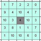
- Width = 3
- Width = 5

- Diameter = 3
- Diameter = 5

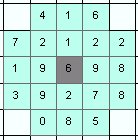
Derives value for the output calls from a neighborhood of cells centered in the output cell. The neighborhood is with user defined shape (square or circle) and size (width or diameter) in number of cells.
Neighborhoods:
Parameters
| Expression | Explanation |
|---|---|
| Function Name | FocalStatistics |
| <InputRaster> | A String - full path to the input raster dataset. |
| <OutputRaster> | A String - full path to the output raster dataset. |
| <StatisticsType> | A String - the type of the statistics to be calculated. Valid values:
|
| <NeighborhoodType> | A String - the neighborhood type. Valid values: Square and Circle. |
| <NeighborhoodSize> | An integer - the side of the square or the diameter of the circle in pixels/number of cells. This should be an odd number. |
ETSPath used in the table below is the full path to ETSRun.exe (E.G. "C:\Program Files\ETSpatial Techniques\ETSurface\ETSRun.exe")
| Language | Syntax |
|---|---|
| Python | subprocess.call([ETSPath, "FocalStatistics", "InputRaster", "OutputRaster", "InputRaster", "NeighborhoodType", "NeighborhoodSize"]) |
| .NET using ETSRun.exe | StartInfo.FileName = ETSPath StartInfo.Arguments = "FocalStatistics" "InputRaster" "OutputRaster" "InputRaster" "NeighborhoodType" "NeighborhoodSize" |
| .NET using ETSOutX.dll | FocalStatistics(InputRaster, OutputRaster, InputRaster, NeighborhoodType, NeighborhoodSize) |
| ArcPy | arcpy.FocalStatistics("InputRaster", "OutputRaster", "InputRaster", "NeighborhoodType", "NeighborhoodSize") |
Notes: