Calculates the cut and fill areas for each polygon from a polygon feature class based on levels for each polygon from a field in the attribute table and the surface defined by a raster.
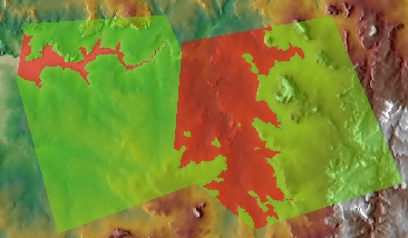
The result of the Cut/Fill function overlaid with the elevation raster.
Parameters
| Expression | Explanation |
|---|---|
| Function Name | RasterViewshed |
| <input raster> | A String representing the input raster dataset. |
| <output raster> | A String - the full name of the output raster. |
| <PolygonLayer> | A String - full path to the polygon layer to be used. |
| {LevelField} | A String representing the name of the field which values are going to be used as level of the input polygons. |
ETSPath used in the table below is the full path to ETSRun.exe (E.G. "C:\Program Files\ETSpatial Techniques\ETSurface\ETSRun.exe")
| Language | Syntax |
|---|---|
| Python | subprocess.call([ETSPath, "RasterViewshed", "input raster", "output raster", "PolygonLayer", "LevelField"]) |
| .NET using ETSRun.exe | StartInfo.FileName = ETSPath StartInfo.Arguments = "RasterViewshed" "input raster" "output raster" "PolygonLayer" "LevelField" |
| .NET using ETSOutX.dll | RasterViewshed(input raster, output raster, PolygonLayer, LevelField) |
| ArcPy | arcpy.RasterViewshed("input raster", "output raster", "PolygonLayer", "LevelField") |
Notes: