
Calculates the slope of each cell of the input raster in percent or degrees. Read more about Slope and its importance here
Source Elevation raster
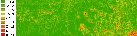
Result Slope raster (Degrees option used)
Parameters
| Expression | Explanation |
|---|---|
| Function Name | RasterSlope |
| <input raster> | A String representing the input raster dataset. |
| <output raster> | A String - the full name of the output raster. |
| <UnitsDegrees> | A Boolean indicating the slope units. If true the slope will be calculated in Degrees, else the output slope will be in Percent. |
ETSPath used in the table below is the full path to ETSRun.exe (E.G. "C:\Program Files\ETSpatial Techniques\ETSurface\ETSRun.exe")
| Language | Syntax |
|---|---|
| Python | subprocess.call([ETSPath, "RasterSlope", "input raster", "output raster", "UnitsDegrees"]) |
| .NET using ETSRun.exe | StartInfo.FileName = ETSPath StartInfo.Arguments = "RasterSlope" "input raster" "output raster" "UnitsDegrees" |
| .NET using ETSOutX.dll | RasterSlope(input raster, output raster, UnitsDegrees) |
| ArcPy | arcpy.RasterSlope("input raster", "output raster", "UnitsDegrees") |
Notes: