Calculates the visibility from a set of observer points to each of the cells of the output raster based on the input surface raster.
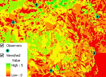
Viewshed from 5 observers symbolized with unique value - the number of observers that can see each cell.
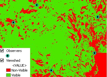
Viewshed from 5 observers classified in 2 classes:
Parameters
| Expression | Explanation |
|---|---|
| Function Name | RasterViewshed |
| <input raster> | A String representing the input raster dataset. |
| <output raster> | A String - the full name of the output raster. |
| <ObserversLayer> | A String - full path to the Observers point layer. |
| {OffsetField} | A String representing the name of the field which values are going to be used as offset of the observers above the raster. |
| {TargetOffset} | A Double indicating the offset of the target above the surface. |
| {CutoffDistance} | A Double representing the Cutoff distance. |
| {UseEarthCurvature} | A Boolean indicating whether the output to be Polyline or PolylineZ feature. |
| {RefractionCorrection} | A Double representing the air refraction coefficient - Default value = 0.13. |
| {RadioWavesCorrection} | A Double representing the radio waves correction coefficient - Default value = 1.333333. |
ETSPath used in the table below is the full path to ETSRun.exe (E.G. "C:\Program Files\ETSpatial Techniques\ETSurface\ETSRun.exe")
| Language | Syntax |
|---|---|
| Python | subprocess.call([ETSPath, "RasterViewshed", "input raster", "output raster", "ObserversLayer", "OffsetField", "TargetOffset", "CutoffDistance", "UseEarthCurvature", "RefractionCorrection", "RadioWavesCorrection"]) |
| .NET using ETSRun.exe | StartInfo.FileName = ETSPath StartInfo.Arguments = "RasterViewshed" "input raster" "output raster" "ObserversLayer" "OffsetField" "TargetOffset" "CutoffDistance" "UseEarthCurvature" "RefractionCorrection" "RadioWavesCorrection" |
| .NET using ETSOutX.dll | RasterViewshed(input raster, output raster, ObserversLayer, OffsetField, TargetOffset, CutoffDistance, UseEarthCurvature, RefractionCorrection, RadioWavesCorrection) |
| ArcPy | arcpy.RasterViewshed("input raster", "output raster", "ObserversLayer", "OffsetField", "TargetOffset", "CutoffDistance", "UseEarthCurvature", "RefractionCorrection", "RadioWavesCorrection") |
Notes: