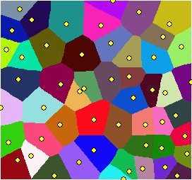
Derives the catchment areas of the input features (Sources). Each cell of the output raster will have the value of the closest (based on straight line distance) Source.
Parameters
| Expression | Explanation |
|---|---|
| Function Name | EucledeanAllocation |
| <InputFeatures> | A String - the full path to the input feature dataset. |
| <output raster> | A String - the full name of the output raster. |
| <CellSize> | A Double representing the cell size of the output raster. |
| <IDField> | A String representing the name of the field in the input point feature class to be used as point ID. |
ETSPath used in the table below is the full path to ETSRun.exe (E.G. "C:\Program Files\ETSpatial Techniques\ETSurface\ETSRun.exe")
| Language | Syntax |
|---|---|
| Python | subprocess.call([ETSPath, "EucledeanAllocation", "InputFeatures", "output raster", "CellSize", "IDField"]) |
| .NET using ETSRun.exe | StartInfo.FileName = ETSPath StartInfo.Arguments = "EucledeanAllocation" "InputFeatures" "output raster" "CellSize" "IDField" |
| .NET using ETSOutX.dll | EucledeanAllocation(InputFeatures, output raster, CellSize, IDField) |
| ArcPy | arcpy.EucledeanAllocation("InputFeatures", "output raster", "CellSize", "IDField") |
Notes: