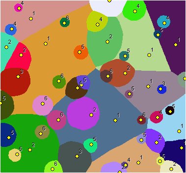
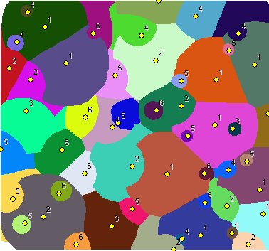
Derives the catchment areas of the input features (Sources) using their spatial location and the weight of each source. The smaller the weight value of a source is, the greater the influence of the source is.
All sources start growing at the same time. A source with weight = 1 increases its area every cycle, a source with weight = 2 every second cycle, a source with weight = 10 every tenth cycle and so on. The process finishes when all cells of the output raster are occupied. If cutoff distance is specified a source will stop increasing its area when it reaches the maximum radius of influence.
Points labeled with their weights. No cutoff distance specified
Points labeled with their weights. Cutoff distance specified
Parameters
| Expression | Explanation |
|---|---|
| Function Name | WeightedVoronoiAllocation |
| <InputFeatures> | A String - the full path to the input feature dataset. |
| <output raster> | A String - the full name of the output raster. |
| <CellSize> | A Double representing the cell size of the output raster. |
| <IDField> | A String representing the name of the field in the input point feature class to be used as point ID. |
| <WeightField> | A String representing the name of the field in the input point feature class that are going to be used as weights. |
| <CutOff> | A Double representing the cut off cost - the value of the cells with larger than this cost (distance x weight) to reach will be set to NODATA. |
ETSPath used in the table below is the full path to ETSRun.exe (E.G. "C:\Program Files\ETSpatial Techniques\ETSurface\ETSRun.exe")
| Language | Syntax |
|---|---|
| Python | subprocess.call([ETSPath, "WeightedVoronoiAllocation", "InputFeatures", "output raster", "CellSize", "IDField", "WeightField", "CutOff"]) |
| .NET using ETSRun.exe | StartInfo.FileName = ETSPath StartInfo.Arguments = "WeightedVoronoiAllocation" "InputFeatures" "output raster" "CellSize" "IDField" "WeightField" "CutOff" |
| .NET using ETSOutX.dll | WeightedVoronoiAllocation(InputFeatures, output raster, CellSize, IDField, WeightField, CutOff) |
| ArcPy | arcpy.WeightedVoronoiAllocation("InputFeatures", "output raster", "CellSize", "IDField", "WeightField", "CutOff") |
Notes: