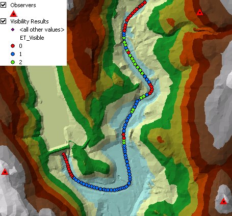
Calculates the visibility from a set of observer points to the features of the target dataset on a reference TIN. If the target dataset is of polyline or polygon type, the visibility to the vertices of the geometries is calculated. The result will be a point dataset (vertices of the targets). For each point the number of observers that can see the point are recorded in the attribute table.
Output - TIN visibility:
Parameters
| Expression | Explanation |
|---|---|
| Function Name | TinVisibility |
| <observers dataset dataset> | A String representing the input observers point feature dataset. |
| <targets dataset> | A String representing the input targets feature dataset. |
| <reference tin> | A String - the full name of the reference TIN dataset. |
| <output dataset> | A String - the full name of the output dataset. |
| {observer offset field} | A String representing the name of the field which values will be used as offset of the observers above the surface. |
| {target offset field} | A String representing the name of the field which values will be used as offset of the targets above the surface. |
| {use earth curvature} | A Boolean indicating if Earth Curvature correction will be applied (default is False). |
| {refraction correction} | A Double representing the air refraction coefficient - Default value = 0.13. |
| {radio waves correction} | A Double representing the radio waves correction coefficient - Default value = 1.333333 |
ETGWPath used in the table below is the full path to ETGWRun.exe (E.G. "C:\Program Files\ETSpatial Techniques\ETSurface\ETSRun.exe")
| Language | Syntax |
|---|---|
| Python | subprocess.call([ETSPath, "TinVisibility", "observers dataset", "targets dataset", "reference tin", "output dataset", "observer offset field", "target offset field", "use earth curvature", "refraction correction", "radio waves correction"]) |
| .NET using ETSRun.exe | StartInfo.FileName = ETSPath StartInfo.Arguments = "TinVisibility" "observers dataset" "targets dataset" "reference tin" "output dataset" "observer offset field" "target offset field" "use earth curvature" "refraction correction" "radio waves correction" |
| .NET using ETSOutX.dll | TinVisibility(observers dataset, targets dataset, reference tin, output dataset, observer offset field, target offset field, use earth curvature, refraction correction, radio waves correction) |
| ArcPy | arcpy.TinVisibility("observers dataset", "targets dataset", "reference tin", "output dataset", "observer offset field", "target offset field", "use earth curvature", "refraction correction", "radio waves correction") |
Notes:
<> - required parameter
{} - optional parameter
The argument separator for StartInfo.Arguments is space. If a string might contain a space, you need to double quote it.