Builds a Triangulated Irregular Network from a feature layer
Notes :
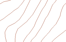
Source Layer (polyline)
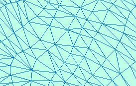
Result TIN
Parameters
| Expression | Explanation |
|---|---|
| Function Name | CreateTin |
| <input dataset> | A String representing the input feature dataset. |
| <output tin> | A String - the full name of the output TIN. |
| <elevation field> | A String representing the name of the field to be used as a source for the elevations. Use "Shape" to use the feature Z values. |
| <triangulation type> | A String - possible values are "Points" and "Hard breaklines". |
ETSPath used in the table below is the full path to ETSRun.exe (E.G. "C:\Program Files\ETSpatial Techniques\ETSurface\ETSRun.exe")
| Language | Syntax |
|---|---|
| Python | subprocess.call([ETSPath, "CreateTin", "input dataset", "output tin", "elevation field", "triangulation type"]) |
| .NET using ETSRun.exe | StartInfo.FileName = ETSPath StartInfo.Arguments = "CreateTin" "input dataset" "output tin" "elevation field" "triangulation type" |
| .NET using ETSOutX.dll | CreateTin(input dataset, output tin, elevation field, triangulation type) |
| ArcPy | arcpy.CreateTin("input dataset", "output tin", "elevation field", "triangulation type") |
Notes:
<> - required parameter
{} - optional parameter
The argument separator for StartInfo.Arguments is space. If a string might contain a space, you need to double quote it.