Go to ET GeoWizards 12.x User Guide
Locate polygon features along routes
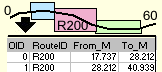
Finds the route and measure information at the geometric intersection of the
input polygon layer and the route layer and creates a line event table.
The output table will contain a route identifier, the FROM and TO measures of
the route on which each polygon was located. If a polygon intersects more than
one route multiple records will be created in the output table for this polygon.
The wizard allows the resulting data to be added to the map as a line event
layer or a standalone table.
Inputs:
- A PolylineM feature layer - the routes to be
used
- Route Identifier field - the values in this
field will be recorded in the output event table
- A Polygon feature layer which features will be
located on the routes
Output:
- A dbf table with event record for each
intersection of a polygon with a route.
- The dbf table will contain all the original
fields of the polygon dataset
- Three new fields will be added
- [ET_KYE] - the route identifier field. The
values will correspond to the route on which each polygon was located
- [ET_FromM] - the FROM measure of each
intersection
- [ET_ToM] - the TO measure of each
intersection
Notes:
- If the option to add the result as an event layer, an additional field
will be available
- [ET_Error] - indicates whether the event was properly located. If the
value in this field indicates some kind of error the shape of the event
point will be empty.
| Copyright © Ianko Tchoukanski |