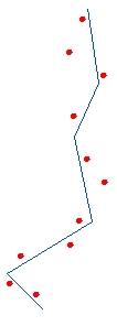
Before Snap
After Snap
Option: Vertices
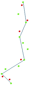
After Snap
Option: Nearest Edge
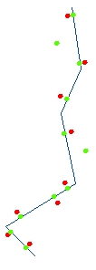
After Snap
Option: Vertices & Edges
Go to ET GeoWizards 12.x User Guide
Go to ToolBox
Implementation
Snaps the features of a point layer to another layer (Point, Polyline or Polygon)
Inputs:
Outputs:
Options:
Notes:
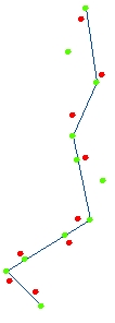
Example:
Before Snap |
After Snap |
After Snap |
After Snap |
|
|
|
|
ToolBox
implementation
(Go to TOP)
Command line syntax
ET_GPSnapPoints <input_dataset> <Reference_dataset> <out_feature_class> <snap_tolerance> {snap_vertices} {snap_nearest}
Parameters
| Expression | Explanation |
|---|---|
| <input_dataset> | A Point feature class or feature layer |
| <Reference_dataset> | A
Point,Polyline or Polygon feature class or feature layer. |
| <out_feature_class> | A String - the full name of the output feature class (A feature class with the same full name should not exist) |
| <snap_tolerance> | A Double representing the Search tolerance (in the units of the input_dataset) to be used |
| {snap_vertices} | A Boolean indicating whether snapping to the closest vertex of the nearest feature from the Reference_dataset to be used |
| {snap_nearest} | A Boolean indicating whether snapping to the nearest point of the nearest feature from the Reference_dataset to be used |
Scripting syntax
ET_GPSnapPoints (input_dataset, Reference_dataset, out_feature_class, snap_tolerance, snap_vertices, snap_nearest)
See the explanations above:
<> - required parameter
{} - optional parameter
| Copyright © Ianko Tchoukanski |