Go to ET GeoWizards 12.x User Guide
Creates rectangles from points in a point dataset and user defined width, height rotation angle and location of the point.
Inputs:
Outputs:
Notes:
Examples:
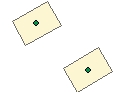
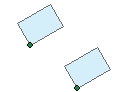
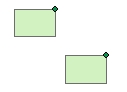
Width
= 300, Height = 200 |
Width
= 300, Height = 200 |
Width = 300,
Height = 200 Angle = 0, Location = "UR" (Upper Right) |
|
|
|
 |
ToolBox
implementation
(Go to TOP)
Command line syntax
ET_GPPointsToRectangles <input_dataset> <out_feature_class> <width_field> <height_field> <angle_field> <LowerLeft | UpperLeft | UpperRight | LowerRight | Center>
Parameters
| Expression | Explanation |
|---|---|
| <input_dataset> | A Point feature class or feature layer |
| <out_feature_class> | A String - the full name of the output feature class (A feature class with the same full name should not exist) |
| <width_field> | A String representing the name of a field in the in the attribute table of the input dataset field name. The field has the values for the width of the rectangles to be created. |
| <height_field> | A String representing the name of a field in the in the attribute table of the input dataset field name. The field has the values for the height of the rectangles to be created. |
| <angle_field> | A String representing the name of a field in the in the attribute table of the input dataset field name. The field has the values for the rotation angle of the rectangles to be created. The angle should be in Decimal Degrees and have Polar orientation - East = 0, anti-clockwise. |
| <LowerLeft | UpperLeft | UpperRight | LowerRight | Center> | Required. A String - This
parameter defines what will be the location of the resulting rectangles
in relation to the original points.. The available options are (Case
sensitive):
|
Scripting syntax
ET_GPPointsToRectangles (input_dataset, out_feature_class,width_field,height_field, angle_field, location_type)
See the explanations above:
<> - required parameter
{} - optional parameter