Go to ET GeoWizards 12.x User Guide
ESRI TIN to PolygonZ
Go to ToolBox
Implementation
Converts an ESRI TIN to PolygonZ feature class. Calculates several characteristics for each triangle.
- Minimum elevation
- Maximum elevation
- Mean elevation
- Slope - identifies the slope, or maximum rate of elevation change for each triangle
- Aspect - the values of the output field represent the compass direction of the aspect; 0
is true north, a 90 degree aspect is to the east etc. For flat triangles (slope = 0)
the value of -1 is assigned for the aspect
- Hill Shade- computes the brightness of each triangle based on a light source location.
Inputs:
- A TIN in ESRI TIN format
- Characteristics to be calculated
- Parameters for Hill Shade ( if Hill Shade option is selected )
- azimuth - the azimuth angle of the light source. The azimuth is expressed in positive
degrees from 0 to 360, measured clockwise from the north. The default is 315 degrees.
- altitude - the altitude angle of the light source above the horizon. The altitude is
expressed in positive degrees, with 0 degrees at the horizon and 90 degrees directly
overhead. The default is 45 degrees.
Outputs:
- New PolygonZ feature class. Several fields are added to the attribute table, depending on
the options selected
- [ET_ElMin] - minimum elevation values for each triangle
- [ET_ElMax] - maximum elevation values for each triangle
- [ET_ElMean] - mean elevation values for each triangle
- [ET_Slope] - the slope of each triangle
- [ET_Aspect] - the aspect of each triangle
- [ET_Hill] - a Hill Shade value for each triangle depending on the input values for
Azimuth and Altitude of the light source
Notes:
- A flat triangle ( Slope = 0 ) will have an Aspect of -1
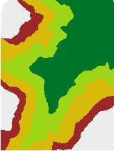
Example: TIN ( PolygonZ ) classified by
| MIN Elevation |
Slope |
 |
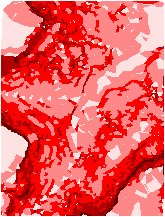 |
| Aspect |
Hill Shade |
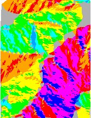  |
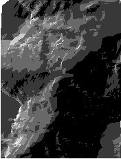 |
ToolBox
implementation
(Go to TOP)
Command line syntax
ET_GPEsriTINToPolygonZ <input_TIN>
<out_feature_class> <Light_Azimuth><Light_Altitude>
Parameters
| Expression |
Explanation |
| <input_TIN> |
A
TIN layer or dataset |
| <out_feature class> |
A String
- the full name of the output feature class (A feature class with the same full
name should not exist) |
| {Light_Azimuth} |
A Double representing the azimuth angle of the light source. The azimuth is expressed in positive
degrees from 0 to 360, measured clockwise from the north. The default is 315 degrees. |
| {Light_Altitude} |
A Double representing the altitude angle of the light source above the horizon. The altitude is
expressed in positive degrees, with 0 degrees at the horizon and 90 degrees directly
overhead. The default is 45 degrees.
|
Scripting syntax
ET_GPEsriTINToPolygonZ (input_TIN out_feature_class
Light_Azimuth Light_Altitude)
See the explanations above:
<> - required parameter
{} - optional parameter
| Copyright © Ianko Tchoukanski |