Go to ET GeoWizards 12.x User Guide
Calibrate routes with points
Adjusts route measures with existing points using measure information stored as
attributes in the Point Attribute Table or the M values of pointM dataset. The
calibration process inserts new vertices to the routes in the places where the
calibration points intersect the routes. The measure value of these vertices is
set to the measure value of the corresponding point. The measures of the
existing vertices is adjusted according to the interpolation/extrapolation
option selected and the adjustment method selected.
Inputs:
- A PolylineM feature layer - to be calibrated
- Route Identifier field
- A Point or PointM feature layer - to be used
for calibration
- Point Route Identifier field
- Point Measure field (only if the measures are
to be taken from a field)
- Search tolerance - only the points that are
closer to the route than this tolerance will be used for calibration
- Interpolation/Extrapolation options
- Adjustment method
- Output Spatial Reference
Output:
- A PolylineM feature class. The measures are
adjusted based on the point dataset and the options selected by the user
Interpolation options:
Three
options are available. They can be used in any combination
- Extrapolate before calibration points - the
measures of the preexisting vertices before the first calibration point will
be adjusted
- Interpolate between calibration points - the
measures of the preexisting vertices between the first and last calibration
points will be adjusted
- Extrapolate after calibration points - the
measures of the preexisting vertices after the last calibration point will
be adjusted
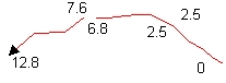
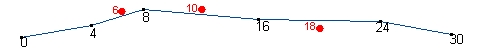 |
Original route and Calibration points |
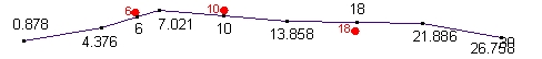 |
All options used for calibration. The measures of the
vertices before, between and after the calibration points are adjusted |
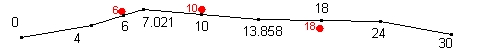 |
Only "Interpolate between" option used. The
vertices before and after calibration points preserve their original
measures |
Adjustment methods:
- Shortest path distance - the distance between the measure points is used
to establish the calibration ratio. Then this ratio is applied to the
preexisting vertices based on their distance to the calibration points.
- The existing measure distance - The measures of the calibration points are
calculated based on the existing measures. This measures are compared to the
new measures to establish the calibration ratio. Then this ratio is applied
to the preexisting vertices based on their M values points.
Notes:
- Spatial Gaps: In many cases a route consists
of disjoined parts A road for example that have the same name on both sides
of a river might be represented by a single route. For such cases the user
has to specify how the spatial gaps between the disjoined parts of the route
will be handled when calculating the measures.
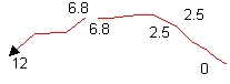 |
Ignore Spatial Gaps option
selected - Continuous measurements |
 |
Ignore Spatial Gaps option not
selected - The gap distance incorporated into the measures. The
straight-line distance between the disjoined nodes added to the measures |
- The user can specify output spatial reference
that is different from the projection of the input dataset. The Output
Spatial Reference must have the same geographic coordinate system as the
input dataset and the calibration points dataset
| Copyright © Ianko Tchoukanski |