Go to ET GeoWizards 12.x User Guide
Create routes from existing polylines
Creates routes by merging existing polylines that have the same common
identifier.
Inputs:
- A Polyline feature layer
- Route Identifier field
- Method for route creation
- Output Spatial Reference
Output:
- A PolylineM feature class. The polylines are
measured depending on the method selected - based on the length of the
polylines, the values of a single field or two fields (From Measure and To
Measure)
Measuring Methods
- Using the lengths of the source
polylines.
- The user controls the direction of the
routes by specifying the coordinate priority of the starting measure
(see notes)
- If there are spatial gaps between the
polylines to be joined, the user specifies whether these gaps to be
taken into account when assigning the measures (see notes)
- Using the values in a single numeric field
- The user controls the direction of the
routes by specifying the coordinate priority of the starting measure
(see notes)
- If there are spatial gaps between the
polylines to be joined, the user specifies whether these gaps to be
taken into account when assigning the measures (see notes)
- Using known measures in two numeric fields.
From Measure and To Measure.
- Very important factor in this case is the
orientation of the original polylines. The polylines must be oriented in
the direction of increasing measure
- Since known measures are used for each
polyline, the Spatial Gaps parameter is not used when using this
method
Notes:
- Spatial Gaps: In many cases a route consists
of disjoined parts A road for example that have the same name on both sides
of a river might be represented by a single route. For such cases the user
has to specify how the spatial gaps between the disjoined parts of the route
will be handled when calculating the measures.
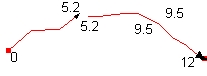
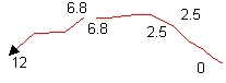
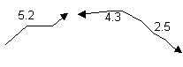 |
Original Polylines |
 |
Ignore Spatial Gaps option
selected - Continuous measurements |
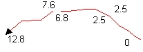 |
Ignore Spatial Gaps option not
selected - The gap distance incorporated into the measures. The
straight-line distance between the disjoined nodes added to the measures |
- The user can specify output spatial reference
that is different from the projection of the input dataset. The Output
Spatial Reference must have the same geographic coordinate system as the
input dataset
| Copyright © Ianko Tchoukanski |