Go to ET GeoWizards 12.x User Guide
Dissolve/Concatenate Event Layers
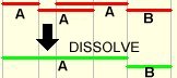
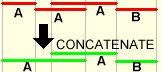
Both Dissolve and Concatenate functions combine records in an event table if the
events are on the same route and have the same value in a specified field. The
functions are available for line event layers only. The wizard allows the
resulting data to be added to the map as a line event layer or a standalone
table.
- Dissolve will combine the events if their
measures overlap
- Concatenate will combine the events if the TO
measure of one event is equal to the FROM measure of the next event
Input:
- An line event layer
- A dissolve/concatenate field - the values of
the records in this field will be used for dissolving/concatenating of the
events
Output:
- A new dbf table with the aggregated
events
- The dbf table will contain all the original
fields of the table of the input event layer
Notes:
- If the option to add the result as an event layer, an additional field
will be available
- [ET_Error] - indicates whether the event was properly located. If the
value in this field indicates some kind of error the shape of the event
point will be empty.
| Copyright © Ianko Tchoukanski |