Go to ET GeoWizards 12.x User Guide
Locate point features along routes
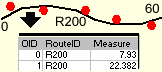
Finds the route and measure information for the points from a Point layer and
creates a point event table. Only the points that are within specified search
tolerance of routes will be recorded in the output table. The output table will
contain a route identifier and a measure for each point. The wizard allows the
resulting data to be added to the map as an event layer or a standalone table.
Inputs:
- A PolylineM feature layer - the routes to be
used
- Route Identifier field - the values in this
field will be recorded in the output event table
- A Point feature layer which points will be
located on the routes
- Search tolerance - only the points that are
closer to the route than this tolerance will be written to the output event
table
Output:
- A dbf table with event record for each point
located.
- The dbf table will contain all the original
fields of the point dataset
- Three new fields will be added
- [ET_KYE] - the route identifier field. The
values will correspond to the route on which each point was located
- [ET_M] - the measure of each point
- [ET_Dist] - the distance of the points from
the routes
Notes:
- If the option to add the result as an event layer, two additional fields
will be available
- [ET_Angle] - the normal angle of the route where the event is
placed
- [ET_Error] - indicates whether the event was properly located. If the
value in this field indicates some kind of error the shape of the event
point will be empty.
| Copyright © Ianko Tchoukanski |