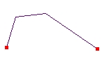
Before Split
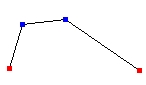
Split in all Vertices
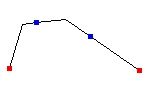
Split in equal segments
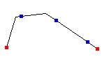
Split with segment length
Go to ET GeoWizards 12.x User Guide
Go to ToolBox
Implementation
Splits the features of a polyline layer.
Inputs:
Outputs:
Notes:
Examples:
Before Split |
Split in all Vertices |
Split in equal segments |
Split with segment length |
|
|
|
|
ToolBox
implementation
(Go to TOP)
Command line syntax
ET_GPSplitPolylines<input_dataset> <out_feature_class> <NumberIntervals | NumberVertices | SegmentLength | EqualLength | Vertex> <split_tolerance>
Parameters
| Expression | Explanation |
|---|---|
| <input_dataset> | A Polyline or Polygon feature class or feature layer |
| <out_feature_class> | A String - the full name of the output feature class (A feature class with the same full name should not exist) |
| <NumberIntervals | NumberVertices | SegmentLength | EqualLength | Vertex> | A String - the split option to be used. |
| <split_tolerance> | Required. A
Double representing depending on the option selected:
|
| {Update_Rules_List} | A String - a list of fields with their update rules. |
Scripting syntax
ET_GPSplitPolylines(input_dataset, out_feature_class, split_option, split_tolerance, Update_Rules_List)
See the explanations above:
<> - required parameter
{} - optional parameter
Example Python script:
|
import arcpy arcpy.ImportToolbox("C:/Program Files/ET SpatialTechniques/ET GeoWizards 11.0 for ArcGIS 10.1/ET GeoWizards.tbx") arcpy.gp.toolbox = "C:/Program Files/ET SpatialTechniques/ET GeoWizards 11.0 for ArcGIS 10.1/ET GeoWizards.tbx" input_dataset = "C:\\data\\streets.shp" result = "C:\\data\\fgdb_test.gdb\\split" arcpy.gp.ET_GPSplitPolylines (input_dataset, result, "SegmentLength",50, "Meters Proportion; Suburb Copy; L_F_ADD Range Address L_T_ADD ;L_T_ADD Range Address L_F_ADD") |
| Copyright © Ianko Tchoukanski |