| Expression |
Explanation |
| <input_dataset> |
A feature class or feature layer |
| <out_file> |
A String
- the full name of the output Google Earth file. The extension (KML or
KMZ) is required and will define whether the result will be compressed
(KMZ) or not (KML). |
| {KML_Description} |
A String that will be used for a general description of the KML file. |
| {label_field} |
A String representing a field name. The values in this field will be
used for naming the Google Earth features.
|
| {description_field} |
Required.
A String representing a field name. The values in this field will be
used for description of the Google Earth features. Read the general Google Earth notes.
|
| {transparency} |
A Double indicating the transparency to be used. 0 = Opaque, 100 =
invisible
|
| {Z_Source} |
A String indicating what will be the source for the elevation values.
Valid strings:
- "Z" - Z values from geometry - Only
if
the exported dataset to be exported has Z values (PointZ, PolylineZ,
PolygonZ).
- "Field
" - Z values from a field - A numeric field is
required
- "Constant" - constant Z values for all features
|
| {z_field} |
A String representing a field name (numeric field). If the Z_Source =
"Field ", the values in this field will be used to get the Z
values.
|
| {z_constant} |
A Double representing the Z values for all features if Z_Source = "Constant"
|
| {z_units} |
A String indicating the units of the Z values of the input dataset.
Valid strings - "Meters" and "Feet".
|
| {z_type} |
A String indicating how the Z values will be interpreted. Valid strings:
- "Absolute" - Sets the altitude of the coordinate relative to sea level, regardless of the
elevation of the Google Earth terrain beneath the feature.
- "Relative" - Sets the altitude of the feature relative to the
Google Earth terrain in a particular location.
- "None" - the Z values are ignored - the feature will be displayed on
the Google Earth surface.
|
| {extrude_geometries} |
A Boolean indicating whether to connect
the geometry to the ground.
|
| {attributes} |
A String that indicates whether and how the attributes will be exported.
Valid strings:
- "Features" - the attributes will be exported
to the actual features
- "Labels" - the attributes will be exported
to the Info - Points
- "Both" - the attributes will be attached to
both, the actual features and the info points
- "None" - no attributes will be exported.
|
| {marker_symbol} |
A String indicating which of the available Google Earth symbols will be
used for point features. The available symbols are:
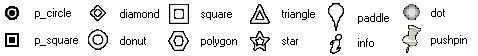
|
| {marker_scale} |
A Double indicating the size of the Icon for the point features.
Actually this is a scale factor for the Google Earth markers - values of
0.5 to 1.5 will give good results.
|
| {line_width} |
A Double representing the width of the Polyline features and outline
width for Polygon features
|
| {export_info_points} |
A Boolean indicating whether the Info-Points will be exported.
|
| {info_symbol} |
A String indicating which of the available Google Earth symbols will be
used for displaying Info-Points. The available symbols are above.
|
| {info_scale} |
A Double indicating the size of the Icon for the Info-Points. Actually
this is a scale factor for the Google Earth markers - values of 0.5 to
1.5 will give good results.
|
| {coordinate_precision} |
An
Integer representing the number of digits after the decimal point for
exported coordinates.
|