Go to ET GeoWizards 12.x User Guide
Build TIN
Go to ToolBox Implementation
Builds a Triangulated Irregular Network from a feature layer
Inputs:
- A feature layer (Point, Polyline, Polygon)
- An elevation field - numeric field that will be used
Outputs:
- New polygon Z feature class. All the polygons are triangles that comply with the Delaunay
criteria. See TIN notes for more information about Triangulated
Irregular Network
Notes :
- The process goes through several steps
- Collecting the elevation points from the source layer. If the source is a polygon or
polyline layer, all the vertices are used.
- Removing duplicate points
- Creating the TIN structure
- Storing the polygons Z
- To achieve best results when creating TIN from a polyline layer use Generalize Polylines
function or Densify
Polylines function in order to remove unnecessary points or add points to the long
straight segments
- The function should work with no problems on
datasets with up to 2 million points.
- For advanced TIN and Raster surfaces creation, check ET Surface at
http://www.ian-ko.com
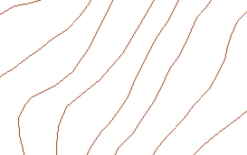
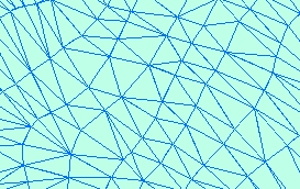
Example:
Source Layer (polyline) |
Result TIN |
|
 |
ToolBox
implementation
(Go to TOP)
Command line syntax
ET_GPBuildTIN <input_dataset>
<out_feature class> <elevation_field>
Parameters
| Expression |
Explanation |
| <input_dataset> |
A
Point, Polyline or Polygon feature class or feature layer |
| <out_feature class> |
A String
- the full name of the output feature class (A feature class with the same full
name should not exist) |
| <elevation_field> |
A
String representing the field name (must be a numeric field) that will
be used as a source for the elevation values |
Scripting syntax
ET_GPBuildTIN (input_dataset, out_feature class,
elevation_field)
See the explanations above:
<> - required parameter
{} - optional parameter
| Copyright © Ianko Tchoukanski |