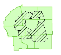
Input Layers
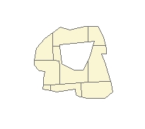
Result
Go to ET GeoWizards 12.x User Guide
Clips a feature layer with the features of a polygon layer
Inputs:
Outputs:
Notes:
Examples:
Input Layers |
Result |
|
|
ToolBox
implementation
(Go to TOP)
Command line syntax
ET_GPClip <input_dataset> <clip_dataset> <out_feature class> <fuzzy_tolerance>
Parameters
| Expression | Explanation |
|---|---|
| <input_dataset> | A Point, Polyline or Polygon feature class or feature layer |
| <clip_dataset> | A
Polygon feature class or feature class. NOTE: The spatial references of <clip_dataset> and the <input_dataset> must have the same Geographic Coordinate System |
| <out_feature class> | A String - the full name of the output feature class (A feature class with the same full name should not exist) |
| <fuzzy_tolerance> | A Double representing the Fuzzy tolerance (in the units of the input dataset) to be used |
Scripting syntax
ET_GPClip (input_dataset, clip_dataset, out_feature class, fuzzy_tolerance)
See the explanations above:
<> - required parameter
{} - optional parameter
| Copyright © Ianko Tchoukanski |