Go to ET GeoWizards 12.x User Guide
Creates a regular polygons grid with user defined extents, tile shape and size.
Inputs:
Outputs:
Notes:
Examples:
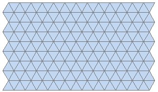
| Shape = Triangle |
|
|
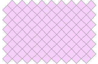
| Shape = Square, Orientation = "Pointy" |
|
|
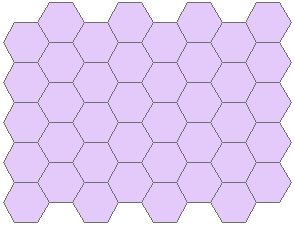
| Shape = Hexagon, Orientation = "Flat" |
|
|
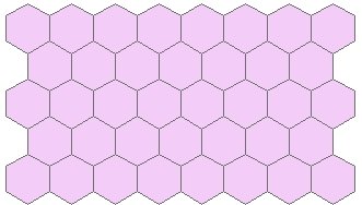
| Shape = Hexagon, Orientation = "Pointy" |
|
|
ToolBox
implementation
(Go to TOP)
Command line syntax - ET_GPCreateTilesExtent
ET_GPCreateTilesExtent <out_feature_class> {out_spatial_reference} <shape_type> {get_extents_from} <Extent> <Size_represents> <Size> {Orientation}
Parameters
| Expression | Explanation |
|---|---|
| <out_feature class> | A String - the full name of the output feature class (A feature class with the same full name should not exist) |
| {out_spatial_reference} | The spatial reference of the output feature class. If not specified the output will be created with Unknown coordinate system |
| <shape_type> | A String controlling the shape type of the output tiles - "Triangle", "Square" or "Hexagon" |
| {get_extents_from} | A String - a layer name or the full name of the a feature class to be used as a source for the extents. |
| <Extent> | An Envelope representing the extents - "XMin YMin XMax YMax" |
| <Size_represents> | Required. A String indicating the
meaning of the <SIZE> parameter
|
| <Size> | A Double representing the size (see above for options) |
| {Orientation} | A String representing the tile orientation - "Flat" or "Pointy" - for Square or Hexagon tiles only. |
Scripting syntax - ET_GPCreateTilesExtent
ET_GPCreateTilesExtent (out_feature_ class, out_spatial_reference, shape_type, get_extents_from, Extent, Size_represents, Size, Orientation)
Command line syntax - ET_GPCreateTilesOrigin
ET_GPCreateTilesOrigin <out_feature_class> {out_spatial_reference} <shape_type> <X_origin> <Y_origin> <Number_columns> <Number_rows> <Size_represents> <Size> {Orientation}
Parameters
| Expression | Explanation |
|---|---|
| <out_feature class> | A String - the full name of the output feature class (A feature class with the same full name should not exist) |
| {out_spatial_reference} | The spatial reference of the output feature class. If not specified the output will be created with Unknown coordinate system |
| <shape_type> | A String controlling the shape type of the output tiles - "Triangle", "Square" or "Hexagon" |
| <X_origin> | A Double representing the X coordinate of the lower left corner of the grid. |
| <Y_origin> | A Double representing the Y coordinate of the lower left corner of the grid. |
| <Number_Columns> | A Long representing the number of columns that the resulting grid will have |
| <Number_Rows> | A Long representing the number of rows that the resulting grid will have |
| <Size_represents> | Required. A String indicating the
meaning of the <SIZE> parameter
|
| <Size> | A Double representing the size (see above for options) |
| {Orientation} | A String representing the tile orientation - "Flat" or "Pointy" - for Square or Hexagon tiles only. |
Scripting syntax - ET_GPCreateTilesOrigin
ET_GPCreateTilesOrigin (out_feature_ class, out_spatial_reference, shape_type, X_origin, Y_origin, Number_Columns, Number_Rows, Size_represents, Size, Orientation)
See the explanations above:
<> - required parameter
{} - optional parameter
| Copyright © Ianko Tchoukanski |