Go to ET GeoWizards 12.x User Guide
Features To Minimum Bounding Rectangles
Creates a bounding rectangle from each feature in the input feature class. Three ways to align the rectangles are available. Attributes of the original features are transferred to the resulting polygons.
Inputs:
Outputs:
Examples:
|
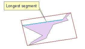
Bounding rectangle aligned with the longest segment of the boundary of the input polygon |
|
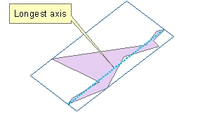
Bounding rectangle aligned with the longest axis of the boundary of the input polygon |
|
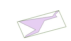
Minimum area bounding rectangle |
ToolBox
implementation
(Go to TOP)
Command line syntax
ET_GPFeaturesToRectangles <input_dataset> <out_feature class><Alignment>
Parameters
| Expression | Explanation |
|---|---|
| <input_dataset> | A Polyline or Polygon feature class or feature layer |
| <out_feature_ class> | A String - the full name of the output feature class (A feature class with the same full name should not exist) |
| {Alignment} | A string defining the
orientation of the rectangles to be created
|
Scripting syntax
ET_GPFeaturesToRectangles (input_dataset, out_feature_ class, Alignment )
See the explanations above:
<> - required parameter
{} - optional parameter
| Copyright © Ianko Tchoukanski |