Go to ET GeoWizards 12.x User Guide
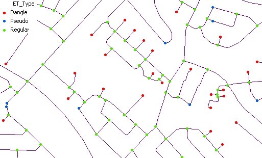
Analyzes the nodes of a polyline layer and exports them as a point feature class.
Inputs:
Outputs:
|
ToolBox
implementation
(Go to TOP)
Command line syntax
ET_GPExportNodes <input_dataset> <out_feature class> <link_field> {export_dangling} {export_pseudo} {export_regular}
Parameters
| Expression | Explanation |
|---|---|
| <input_dataset> | A Polyline feature class or feature layer |
| <out_feature class> | A String - the full name of the output feature class (A feature class with the same full name should not exist) |
| <link_field> | A String representing the name of the field that will be attached to the point attribute table. If for example the function is used to export the nodes of a street dataset and the "StreetName" is the field name to be used for each point in the point attribute table will be recorded all the streets that intersect in this node. |
| {export_dangling} | A Boolean indicating whether the dangling nodes will be exported |
| {export_pseudo} | A Boolean indicating whether the pseudo nodes will be exported |
| {export_regular} | A Boolean indicating whether the regular nodes will be exported |
Scripting syntax
ET_GPExportNodes (input_dataset, out_feature class, link_field, export_dangling, export_pseudo, export_regular)
See the explanations above:
<> - required parameter
{} - optional parameter