Rotational angle = "Along the longest Side"
Go to ET GeoWizards 12.x User Guide
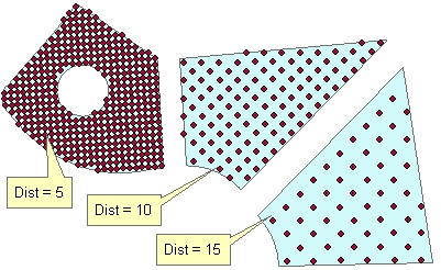
Generates uniform (regularly spaced) points located in the polygons of the input polygon dataset. The distance between the points for each polygon can be the same or different - based on the values in a numeric field of the input polygon feature class. The user can specify the rotation angle for the resulting point grid.
Inputs:
Outputs:
Illustration:
| Distance between points = 10, Rotational angle = 0 |
|
|
|
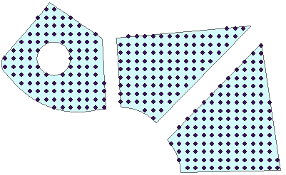
Original polygons labeled with the values in
field to be used as a source for getting the distance between the points. Rotational angle = "Along the longest Side" |
|
|
ToolBox
implementation
(Go to TOP)
Command line syntax
ET_GPPointGridsInPolygons<input_dataset> <out_feature_class> {distance} {distance_field} {angle_from} {rotation_angle} {angle_field}
Parameters
| Expression | Explanation |
|---|---|
| <input_dataset> | A Polygon feature class or feature layer |
| <out_feature_class> | A String - the full name of the output feature class. |
| {distance} | A Double representing the distance between the points for all polygons |
| {distance_field} | A String representing the name of a numeric field which values will be used to get the distance between the points for each polygon |
| {angle_from} | A String defining how the rotation
angle will be specified
|
| {rotation_angle} | A Double - specifying the rotation angle for all polygons. |
| {angle_field} | A String - the name of the field to be used as source for rotation angle. |
Scripting syntax
ET_GPPointGridsInPolygons(input_dataset, out_feature_class, distance, distance_field, angle_from, rotation_angle, angle_field)
See the explanations above:
<> - required parameter
{} - optional parameter
| Copyright © Ianko Tchoukanski |