Go to ET GeoWizards 12.x User Guide
Creates regular polygons from points in a point dataset and user defined number of sides, size and rotation angle. The source point will be located in the center of the polygons.
Inputs:
Outputs:
Notes:
Examples:
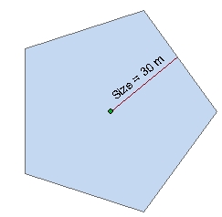
Size = 30 , Angle = 0,
Number sides = 5 |
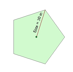
Size = 30 , Angle = 0,
Number sides = 5 |
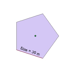
Size = 30 , Angle = 0, Number sides = 5 Option - Side |
|
|
|
 |
|
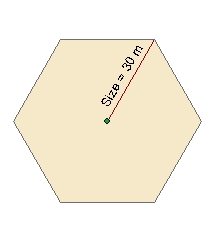
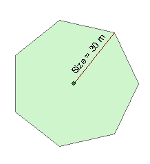
Size = 30 , Angle = 0, Number sides = 6 Option - Radius Circumscribed |
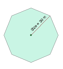
Size = 30 , Angle = 0, Number sides = 7 Option - Radius Circumscribed |
Size = 30 , Angle = 0, Number sides = 8 Option - Radius Circumscribed |
 |
 |
 |
ToolBox
implementation
(Go to TOP)
Command line syntax
ET_GPPointsToRegularPolygons <input_dataset> <out_feature_class> <number_sides> <Radius In | Radius Out | Side> <Size> <size_field> <rotation_angle>
Parameters
| Expression | Explanation |
|---|---|
| <input_dataset> | A Point feature class or feature layer |
| <out_feature_class> | A String - the full name of the output feature class (A feature class with the same full name should not exist) |
| <number_sides> | An Integer defining the number of sides of the polygons to be created. |
| <Radius In | Radius Out | Side> | Required. A String indicating the
meaning of the <SIZE> parameter
|
| <Size> | A Double representing the size (see above for options) |
| <size_field> | A String representing the name of a field in the in the attribute table of the input dataset. The field has the values for the size of the polygons to be created. |
| {rotation_angle} | A Double representing the rotation angle (see above) |
Scripting syntax
ET_GPPointsToRegularPolygons (input_dataset, out_feature_class,number_sides,size_represents, size, size_field, rotation_angle)
See the explanations above:
<> - required parameter
{} - optional parameter