Go to ET GeoWizards 12.x User Guide
Polygon To Polyline Advanced
Go to ToolBox
Implementation
Converts the polygon boundaries to polylines.
- Creates a topologically correct (nodes at
intersections, no overlaps) Polyline feature class
- For each polyline the left and right polygon attributes are
added.
- Optionally the labels of the polygons are exported as points. The point attribute table contains all original
attributes.
Inputs:
- A polygon feature layer
- Link Field - the values of this field will be
saved as Left and Right polygons for each polyline
- Fuzzy tolerance - will be used to clean the
polygon boundaries
Outputs:
- New topologically correct Polyline feature class.
Fields added to the polyline attribute table
- [ET_Left] - stores the Left polygon link
values
- [ET_Right] - stores the Right polygon link
values
- Optional Point feature class representing the
labels of the input polygons. The attributes of the input polygons are
preserved in the Point Attribute Table
Notes :
- The default Fuzzy tolerance is calculated from the extents of the input layer using the
formulae (W + H) / 2000000 where W and H are the with and height of the extent envelope.
- Larger values of the Fuzzy tolerance may be used to clean some bigger Gaps and Slivers, but it might lead to unwanted approximation of the input shapes.
- A Fuzzy tolerance of 0 will be replaced
by the default value
- If a polyline does not have Left polygon, the
value of the ET_Left field will be set to -999999999. In topologically
correct polygon dataset this should indicate the outer boundary (neighboring
with the so-called Universal Polygon. Values of -999999999 in the interior
of the polygon dataset will indicate gaps or overlaps in the data.
- If the input feature class has multi-part
features and the Object ID field is used as a link field, the polylines will
have for Left and Right polygons the IDs of the original polygons. The label
points however will carry in the ET_ID field the IDs of the exploded
polygons.
Example:
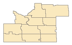 |
Original polygons |
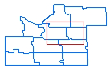 |
Derived polylines.
- Nodes in intersections
- No duplicates
- The polylines on the boundary of the area will have ET_Left =
-999999999
|
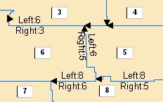 |
Polylines labeled with their Left
and Right polygons. Polygons labeled with the Link field used in the
function. |
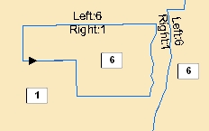 |
Multi-part polygons. Object ID
used in the function as a link field. |
ToolBox
implementation
(Go to TOP)
Command line syntax
ET_GPPolygonToPolylineAdvanced
<input_dataset>
<out_feature_class><fuzzy_tolerance> <link_field> {label_feature_class}
Parameters
| Expression |
Explanation |
| <input_dataset> |
A
Polyline feature class or feature layer |
| <out_feature_class> |
A String
- the full name of the output feature class. |
| <fuzzy_tolerance> |
A
Double - the gaps smaller than this
tolerance will be closed. The units of the parameter are in the spatial
reference of the input feature class
|
| <link_field> |
A String - the
name of the field to be used as a link. The field must exists in the input
feature class. The type of the field can be Short Integer , Long
Integer, Double, Single, String or Object ID. The values of this field
will be saved as Left and Right polygons for each polyline.
|
| {label_feature_class} |
A String
- the full name of the label feature class.
|
Scripting syntax
ET_GPCleanContourGaps (input_dataset, out_feature_ class,
fuzzy_tolerance, link_field,label_feature_class)
See the explanations above:
<> - required parameter
{} - optional parameter
| Copyright © Ianko Tchoukanski |