Go to ET GeoWizards 12.x User Guide
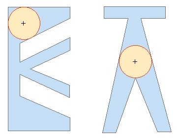
Polygons to Maximum Inscribed Circles
Creates from each polygon in the input feature class a circular polygon representing the circle with maximum radius that can be inscribed in the input polygon. The center of the is located in the "deepest" point of each polygon. Attributes of the original features are transferred to the resulting polygons.
Inputs:
Outputs:
Note:
The function uses an interpolation algorithm and the precision of the calculation might not be 100%
Examples:
| Example 1 |
|
|
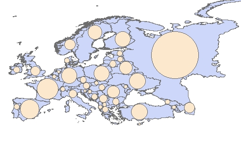
| Example 2 - Europe |
|
|
ToolBox
implementation
(Go to TOP)
Command line syntax
ET_GPPolygonToMaxInscribedCircles <input_dataset> <out_feature class>
Parameters
| Expression | Explanation |
|---|---|
| <input_dataset> | A Polygon feature class or feature layer |
| <out_feature_ class> | A String - the full name of the output feature class (A feature class with the same full name should not exist) |
Scripting syntax
ET_GPPolygonToMaxInscribedCircles (input_dataset, out_feature_ class )
See the explanations above:
<> - required parameter
{} - optional parameter
| Copyright © Ianko Tchoukanski |