Go to ET GeoWizards 12.x User Guide
Reverse Geocoding
Uses a reference polyline (street centerlines) layer to assign addresses to the points
from a point layer. Allows transfer of any additional attributes.
Inputs:
- A point layer which features are to be assigned addresses
- A reference polyline layer that will be used as a source for the addresses
- The type of address data
- Single
- Range Continuous - From and To address fields expected
- Range Address - Two pairs (Left & Right) address fields expected. The side of the
points taken into account.
- Search distance
- Additional fields to be transferred to the points
Outputs:
- A point feature class with addresses assigned to the points
Notes:
- Range attributes from string and numeric fields can be handled. The records that have
range values containing non numeric characters will not be used.
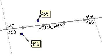
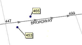
Example:
Address range |
Single range |
 |
 |
| Copyright © Ianko Tchoukanski |