Go to ET GeoWizards 12.x User Guide
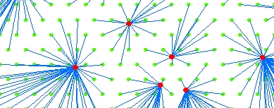
Creates a polyline feature class representing the shortest distance between centers (point dataset) and Destinations (Point, Polyline or Polygon datasets). The Destinations are allocated to the closest Center.
Inputs:
Outputs:
Notes:
ToolBox
implementation
(Go to TOP)
Command line syntax
ET_GPSpiderDiagram <centers_dataset>
<Destination_dataset> <out_feature class> <Cutoff_distance> {output_spatial_reference}
Parameters
| Expression | Explanation |
|---|---|
| <centers_dataset> | A Point feature class or feature layer |
| <Destination_dataset> | A Point, Polyline or Polygon feature class or feature layer. |
| <out_feature class> | A String - the full name of the output feature class (A feature class with the same full name should not exist) |
| <Cutoff_distance> | A Double representing the Search tolerance (in the units of the {output_spatial_reference} to be used |
| {output_spatial_reference} | The
spatial reference in which the calculations will be performed. If not
specified the spatial reference of the input dataset will be used. NOTE: The spatial references of the <centers_dataset>, <Destination_dataset> and {output_spatial_reference} must have the same Geographic Coordinate System |
Scripting syntax
ET_GPSpiderDiagram (centers_dataset, Destination_dataset, out_feature class, Cutoff_distance, output_spatial_reference)
See the explanations above:
<> - required parameter
{} - optional parameter
| Copyright © Ianko Tchoukanski |